Datasets
Displaying 1 - 10 of 10

The C3S Arctic Regional Reanalysis second generation (CARRA2) dataset contains daily and monthly meteorological variables at 2.5 km resolution. These variables are specified at single levels (including surface) and also at soil, height, pressure and model levels. These daily and monthly data are pre-calculated and have the following types depending on the variables: daily and monthly averages, extremes and totals.
Interval/period: Wed, 01/01/1986 - Sun, 12/31/2023

The C3S Arctic Regional Reanalysis second generation (CARRA2) dataset contains 3-hourly analyses at 2.5 km resolution. These variables are specified at single levels (including surface) and also at soil, height, pressure and model levels. Additionally, hourly forecasts are available between the analysis times and particularly forecasts up to 18 hours initialised from the analyses at 00 and 12 UTC.
Interval/period: Wed, 01/01/1986 - Sun, 12/31/2023

The daily and monthly data of the C3S Arctic Regional Reanalysis (CARRA) dataset contains daily and monthly meteorological variables at 2.5 km resolution. This includes fields at the single levels (including surface) and on pressure, height, soil and model levels.
These daily and monthly data are pre-calculated and have the following types depending on the variables: daily and monthly averages, extremes and totals.
These daily and monthly data are pre-calculated and have the following types depending on the variables: daily and monthly averages, extremes and totals.
Interval/period: Sat, 09/01/1990 - Sat, 02/28/2026
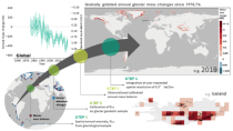
The dataset provides global annual glacier mass changes distributed on a global regular grid at 0.5° resolution (latitude, longitude) based on the Fluctuations of Glaciers (FoG) database of the World Glacier Monitoring Service (WGMS). Glaciers play a fundamental role in the Earth’s water cycles. They are one of the most important freshwater resources for societies and ecosystems and the recent increase in ice melt contributes directly to the rise of ocean levels.
Interval/period: Wed, 01/01/1975 - Sat, 05/09/2026
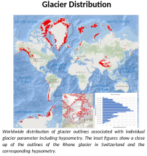
This dataset, commonly known as the Randolph Glacier Inventory (RGI), provides global glacier outlines compiled from maps, aerial photographs and satellite images. The data is provided as a "snapshot" (single time-slice) constructed from images that were mostly acquired in the period 2000-2010.
Interval/period: Sat, 01/01/2000 - Sun, 12/31/2000
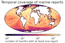
This set of holdings provides access to surface marine meteorological weather reports and observations made by merchant
and naval ships, drifting buoys and other platforms and vessels over
the global ocean. Data have been collated and harmonised and quality control checks have been performed, but no attempt
has been made to assess or correct for potential biases.
Data are provided for a range of commonly observed variables.
Interval/period: Tue, 01/01/1850 - Sat, 05/09/2026
This dataset provides a complete archive of monthly mass change timeseries for the drainage basins of the Antarctic and Greenland Ice Sheets from NASA's Gravity Recovery and Climate Experiment (GRACE) and GRACE Follow On (GRACE-FO) mission, which have operated from 2002 to current data.
Interval/period: Wed, 01/01/2003 - Sat, 12/31/2022
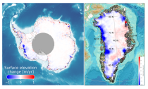
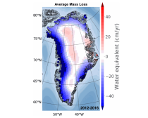
This dataset provides estimates of surface elevation change over the Greenland and Antarctic ice sheets since 1992, utilizing satellite radar altimetry from five missions: ERS-1, ERS-2, ENVISAT, CryoSat-2, and Sentinel-3A. The surface elevation change is modelled over successive, overlapping periods and reported monthly.
Interval/period: Wed, 01/01/1992 - Sat, 05/09/2026
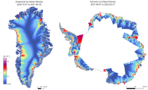
This dataset provides annual ice velocity maps of the Greenland and Antarctic Ice Sheets derived from Sentinel-1 data. The product represents the current state-of-the-art in Europe for satellite-based ice velocity data records. It follows from the European Space Agency (ESA) Climate Change Initiative (CCI) and is guided by the Global Climate Observing System (GCOS) targets for the Ice Sheets Essential Climate Variable (ECV).
Interval/period: Sun, 10/01/2017 - Sat, 05/09/2026
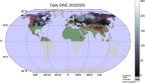
Snow water equivalent (SWE) is an important variable indicating the amount of accumulated snow on land surfaces. SWE describes the amount of liquid water in a snowpack that would be formed if the snowpack was completely melted. This dataset is useful for monitoring snow conditions, freshwater storage, and climate studies. It provides daily estimates of SWE for the Northern Hemisphere from 1979 to present derived from passive microwave radiometer (PMR) measurements onboard polar-orbiting satellites.
Interval/period: Tue, 01/02/1979 - Sat, 05/09/2026