Datasets

Interval/period: Thu, 06/01/1995 - Sat, 05/09/2026

Interval/period: Wed, 01/01/1992 - Sat, 05/09/2026

Interval/period: Mon, 01/01/1979 - Wed, 04/01/2026

Interval/period: Sun, 01/01/1950 - Tue, 12/31/2019

Interval/period: Wed, 01/01/1986 - Sun, 12/31/2023

Interval/period: Wed, 01/01/1986 - Sun, 12/31/2023

Interval/period: Mon, 01/01/1979 - Mon, 09/30/2024

Interval/period: Sat, 01/01/2000 - Sun, 12/31/2017

combined with observations using the UERRA-HARMONIE system and MESCAN-SURFEX system.
UERRA-HARMONIE is a 3-dimensional data assimilation system, whereas
MESCAN-SURFEX is a complementary surface analysis system. In general, the
assimilation systems are able to estimate biases between observations and to
sift good-quality data from poor data. The laws of physics allow for estimates
Interval/period: Thu, 10/18/2018 - Wed, 07/31/2019

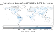
River discharge
Volumetric soil moisture
Snow water equivalent
Soil wetness index (root zone)
Runoff water equivalent (surface plus subsurface)
Interval/period: Thu, 10/11/2018 - Mon, 04/06/2026

This dataset provides gridded modelled hydrological time series forced with medium-range meteorological forecasts. The data is a consistent representation of the most important hydrological variables across the European Flood Awareness System (EFAS) domain. The temporal resolution is sub-daily high-resolution and ensemble forecasts of:
River discharge
Soil moisture for three soil layers
Snow water equivalent
Interval/period: N/A
River discharge
Soil wetness index (root zone)
Snow water equivalent
Runoff water equivalent (surface plus subsurface)
Interval/period: Tue, 11/05/2019 - Thu, 05/07/2026

River discharge
Volumetric soil moisture
Snow water equivalent
Soil wetness index (root zone)
Runoff water equivalent (surface plus subsurface)
Interval/period: Tue, 01/01/1991 - Tue, 05/05/2026
River discharge
Soil wetness index (root zone)
Snow water equivalent
Runoff water equivalent (surface plus subsurface)
Interval/period: Mon, 01/01/1979 - Tue, 05/05/2026

River discharge
Volumetric soil moisture
Snow water equivalent
Soil wetness index (root zone)
Runoff water equivalent (surface plus subsurface)
Interval/period: Wed, 10/14/2020 - Sat, 05/09/2026

Interval/period: Sun, 01/03/1999 - Sat, 11/25/2023

These daily and monthly data are pre-calculated and have the following types depending on the variables: daily and monthly averages, extremes and totals.
Interval/period: Sat, 09/01/1990 - Sat, 02/28/2026

Interval/period: Wed, 01/01/2003 - Wed, 12/03/2025

Emissions of atmospheric pollutants from biomass burning and vegetation fires are key drivers of the evolution of atmospheric composition, with a high degree of spatial and temporal variability, and an accurate representation of them in models is essential.
Interval/period: N/A
Interval/period: Sat, 01/01/2000 - Thu, 12/31/2020

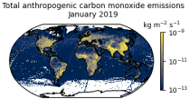
This data set contains gridded distributions of global anthropogenic and natural emissions.
Interval/period: N/A
Interval/period: Mon, 01/01/1979 - Tue, 12/31/2024

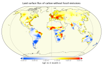
This data set contains net fluxes at the surface, atmospheric mixing ratios at model levels, and column-mean atmospheric mixing ratios for carbon dioxide (CO2), methane (CH4) and nitrous oxide (N20).
Interval/period: N/A
Interval/period: Sat, 09/01/1984 - Sat, 01/31/2026
Interval/period: Sat, 09/01/1984 - Sat, 01/31/2026