ERA5 is the fifth generation ECMWF reanalysis for the global climate and weather for the past 8 decades.
Data is available from 1940 onwards.
ERA5 replaces the ERA-Interim reanalysis.

calendar_today Interval/period: Mon, 01/01/1940 - Sat, 05/02/2026

ERA5 is the fifth generation ECMWF reanalysis for the global climate and weather for the past 8 decades.
Data is available from 1940 onwards.
ERA5 replaces the ERA-Interim reanalysis.

calendar_today Interval/period: Mon, 01/01/1940 - Sat, 05/02/2026

ERA5 is the fifth generation ECMWF reanalysis for the global climate and weather for the past 8 decades.
Data is available from 1940 onwards. ERA5 replaces the ERA-Interim reanalysis.

calendar_today Interval/period: Mon, 01/01/1940 - Fri, 12/06/2024

ERA5-Land is a reanalysis dataset providing a consistent view of the evolution of land variables over several decades at an enhanced resolution compared to the
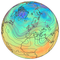
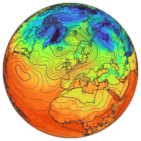
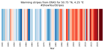
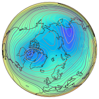
Fifth Generation of the European Centre for Medium-Range Weather Forecasts (ECMWF) Reanalysis (ERA5).
Produced by replaying only the land component of the ECMWF ERA5 climate reanalysis, it benefits from the same physical data-assimilation framework but runs offline at
higher spatial detail (9 km grid) to deliver richer land-surface information.

calendar_today Interval/period: Sun, 01/01/1950 - Thu, 12/31/2026

ERA5 is the fifth generation ECMWF reanalysis for the global climate and weather for the past 8 decades.
Data is available from 1940 onwards.
ERA5 replaces the ERA-Interim reanalysis.

calendar_today Interval/period: Mon, 01/01/1940 - Wed, 04/01/2026

ERA5 is the fifth generation ECMWF reanalysis for the global climate and weather for the past 8 decades.
Data is available from 1940 onwards.
ERA5 replaces the ERA-Interim reanalysis.

calendar_today Interval/period: Mon, 01/01/1940 - Wed, 04/01/2026

ERA5 is the fifth generation ECMWF reanalysis for the global climate and weather for the past 8 decades.
Data is available from 1940 onwards.
ERA5 replaces the ERA-Interim reanalysis.

calendar_today Interval/period: Mon, 01/01/1940 - Sat, 05/02/2026

ERA5 is the fifth generation ECMWF reanalysis for the global climate and weather for the past 8 decades.
Data is available from 1940 onwards.
ERA5 replaces the ERA-Interim reanalysis.

calendar_today Interval/period: Mon, 01/01/1940 - Sat, 05/02/2026

ERA5-Land is a reanalysis dataset providing a consistent view of the evolution of land variables over several decades at an enhanced resolution compared to ERA5. ERA5-Land has been produced by replaying the land component of the ECMWF ERA5 climate reanalysis. Reanalysis combines model data with observations from across the world into a globally complete and consistent dataset using the laws of physics. Reanalysis produces data that goes several decades back in time, providing an accurate description of the climate of the past.

calendar_today Interval/period: Sun, 01/01/1950 - Sat, 05/02/2026

ERA5-Land is a reanalysis dataset providing a consistent view of the evolution of land variables over several decades at an enhanced resolution compared to ERA5. ERA5-Land has been produced by replaying the land component of the ECMWF ERA5 climate reanalysis. Reanalysis combines model data with observations from across the world into a globally complete and consistent dataset using the laws of physics. Reanalysis produces data that goes several decades back in time, providing an accurate description of the climate of the past.

calendar_today Interval/period: Sun, 01/01/1950 - Wed, 04/01/2026

ERA5-Land is a reanalysis dataset providing a consistent view of the evolution of land variables over several decades at an enhanced resolution compared to ERA5. ERA5-Land has been produced by replaying the land component of the ECMWF ERA5 climate reanalysis. Reanalysis combines model data with observations from across the world into a globally complete and consistent dataset using the laws of physics. Reanalysis produces data that goes several decades back in time, providing an accurate description of the climate of the past.

calendar_today Interval/period: Sun, 01/01/1950 - Sat, 05/02/2026

Atmospheric water vapor, quantified here as Total Column Water Vapor (TCWV), holds paramount importance in monitoring and understanding Earth's climate dynamics. Its role as an Essential Climate Variable is pivotal, serving as the foundation for cloud formation, cloud physics, and significantly impacting the Earth's heat budget through its proficient absorption of both long and short-wave radiation.
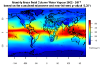
This catalogue entry presents two extensive, high-quality observational datasets of TCWV, specifically tailored for climate analysis and applications.

calendar_today Interval/period: Tue, 01/01/2002 - Sun, 12/31/2017

This catalogue entry provides the gridded climate data (monthly/annual timeseries) used for the Copernicus Climate Change Service Atlas (C3S Atlas). The gridded datasets consist of in-situ and satellite observation-based datasets, reanalyses (CERRA, ERA5, ERA5-Land, and ORAS5) and global (CMIP5 and CMIP6) and regional (CORDEX) climate projections for the variables and indices included in the C3S Atlas.

calendar_today Interval/period: Sun, 01/01/1860 - Mon, 12/31/2300

This catalogue entry provides gridded data from global (CMIP5 and CMIP6) and regional (CORDEX) projections for the set of 22 variables and indices included in the IPCC Interactive Atlas, a novel contribution from Working Group I (WGI) to the IPCC Sixth Assessment Report (AR6). These variables and indices are relevant for the climatic impact-drivers used in the regional assessments conducted in AR6 (Chapters 10, 11, 12 and Atlas), related to heat and cold, wet and dry, snow and ice, and wind.

calendar_today Interval/period: Sun, 01/01/1860 - Mon, 12/31/2300

Water vapour is has been recognised as an Essential Climate Variable as it provides the basis for all cloud formation and physics and furthermore influences the Earth's heat budget due to its high absorbance of long and short-wave radiation. Total column water vapour (TCWV) is a measure of the integrated water vapour content of the atmosphere.
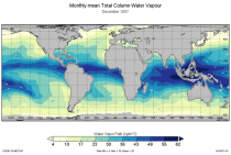
This catalogue entry provides the TCWV data product usually called Hamburg Ocean Atmosphere Parameters and Fluxes from Satellite Data (HOAPS).

calendar_today Interval/period: Wed, 05/01/2002 - Thu, 03/01/2012

ERA5–Drought is a global reconstruction of drought indices from 1940 to present.
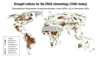
The dataset comprises two standardised drought indices:
- the Standardised Precipitation Index (SPI)
- the Standardised Precipitation-Evapotranspiration Index (SPEI).

calendar_today Interval/period: Mon, 01/01/1940 - Sun, 03/01/2026

This dataset provides meteorological and snow indicators for Europe, characterizing operating conditions of winter ski resorts under past and future climate scenarios. The dataset consists of 39 indicators of atmospheric and snow conditions computed in a similar manner for all mountain regions in Europe at the scale of NUTS-3 regions (Nomenclature of Territorial Units for Statistics) and by steps of 100 m elevation.

calendar_today Interval/period: Sun, 01/01/1950 - Fri, 01/01/2100

This dataset provides hydrological seasonal forecasts of monthly mean river discharge across Europe. Two hydrological model ensembles are provided. The first is an E-HYPE multi-model system comprising eight model realisations using a catchment-based resolution. The second comprises the E-HYPEgrid, VIC-WUR and EFAS (LISFLOOD) hydrological models at a 5km gridded resolution.

calendar_today Interval/period: Tue, 12/01/2020 - Wed, 04/01/2026

This dataset provides hydrological seasonal reforecasts of monthly mean river discharge across Europe for the period 1993 to 2016. The first is an E-HYPE multi-model system comprising eight model realisations using a catchment-based resolution. The second comprises the E-HYPEgrid, VIC-WUR and LISFLOOD-EFAS hydrological models at a 5km gridded resolution.

calendar_today Interval/period: Fri, 01/01/2021 - Sun, 05/10/2026

This entry covers pressure-level data post-processed for bias adjustment on a monthly time resolution.

calendar_today Interval/period: Sun, 01/01/2017 - Fri, 05/01/2026

This entry covers single-level data post-processed for bias adjustment on a monthly time resolution.

calendar_today Interval/period: Sun, 01/01/2017 - Fri, 05/01/2026

This entry covers single-level data and soil-level data at the original time resolution (once a day, or once every 6 hours, depending on the variable).

calendar_today Interval/period: Thu, 01/01/1981 - Fri, 05/01/2026

This entry covers pressure-level data aggregated on a monthly time resolution.

calendar_today Interval/period: Thu, 01/01/1981 - Fri, 05/01/2026

This entry covers single-level data aggregated on a monthly time resolution.

calendar_today Interval/period: Thu, 01/01/1981 - Fri, 05/01/2026

This entry covers pressure-level data at the original time resolution (once every 12 hours).

calendar_today Interval/period: Thu, 01/01/1981 - Fri, 05/01/2026