Datasets
Displaying 51 - 61 of 61
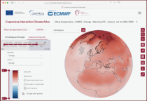
This catalogue entry provides the gridded climate data (monthly/annual timeseries) used for the Copernicus Climate Change Service Atlas (C3S Atlas). The gridded datasets consist of in-situ and satellite observation-based datasets, reanalyses (CERRA, ERA5, ERA5-Land, and ORAS5) and global (CMIP5 and CMIP6) and regional (CORDEX) climate projections for the variables and indices included in the C3S Atlas.
Interval/period: Sun, 01/01/1860 - Mon, 12/31/2300
This catalogue entry provides gridded data from global (CMIP5 and CMIP6) and regional (CORDEX) projections for the set of 22 variables and indices included in the IPCC Interactive Atlas, a novel contribution from Working Group I (WGI) to the IPCC Sixth Assessment Report (AR6). These variables and indices are relevant for the climatic impact-drivers used in the regional assessments conducted in AR6 (Chapters 10, 11, 12 and Atlas), related to heat and cold, wet and dry, snow and ice, and wind.
Interval/period: Sun, 01/01/1860 - Mon, 12/31/2300
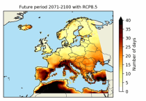
The dataset contains the number of hot and cold spell days using different European-wide and national/regional definitions developed within the C3S European Health service.
These heat wave and cold spell days are available for different future time periods and use different climate change scenarios.
These heat wave and cold spell days are available for different future time periods and use different climate change scenarios.
Interval/period: Wed, 01/01/1986 - Mon, 12/31/2085
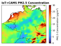
This dataset provides surface-level particulate matter (PM2.5 and PM10) concentrations derived from in situ low-cost sensor (LCS) measurements, produced by the European Centre for Medium-Range Weather Forecasts (ECMWF) in the context of the Horizon Europe All Data for Green Deal project. This dataset differs from existing air quality datasets by combining crowdsourced observations with a robust correction framework, producing high-resolution, reference-aligned gridded products.
Interval/period: Mon, 01/01/2018 - Tue, 12/31/2024
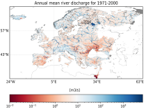
This dataset provides water variables and indicators based on hydrological impact modelling, forced by bias adjusted regional climate simulations from the European Coordinated Regional Climate Downscaling Experiment (EURO-CORDEX). The dataset contains Essential Climate Variable (ECV) data in the form of daily mean river discharge and a set of climate impact indicators (CIIs) for both water quantity and quality.
ECV datasets provide the empirical evidence needed to understand the current climate and predict future changes.
ECV datasets provide the empirical evidence needed to understand the current climate and predict future changes.
Interval/period: N/A

This entry covers pressure-level data post-processed for bias adjustment on a monthly time resolution.
Interval/period: Sun, 01/01/2017 - Fri, 05/01/2026

This entry covers single-level data post-processed for bias adjustment on a monthly time resolution.
Interval/period: Sun, 01/01/2017 - Fri, 05/01/2026

This entry covers single-level data and soil-level data at the original time resolution (once a day, or once every 6 hours, depending on the variable).
Interval/period: Thu, 01/01/1981 - Fri, 05/01/2026

This entry covers pressure-level data aggregated on a monthly time resolution.
Interval/period: Thu, 01/01/1981 - Fri, 05/01/2026
This entry covers single-level data aggregated on a monthly time resolution.
Interval/period: Thu, 01/01/1981 - Fri, 05/01/2026

This entry covers pressure-level data at the original time resolution (once every 12 hours).
Interval/period: Thu, 01/01/1981 - Fri, 05/01/2026