Datasets

Interval/period: Sat, 09/01/1984 - Thu, 07/31/2025
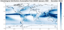
Interval/period: Tue, 01/01/2002 - Sat, 12/31/2022

Lower values mean that more radiation is absorbed at the earth's surface while higher values mean more is reflected back to space. Albedo depends on the characteristics of the underlying surface and...
Interval/period: N/A

These daily and monthly data are pre-calculated and have the following types depending on the variables: daily and monthly averages, extremes and totals.
Interval/period: Sat, 09/01/1990 - Sat, 02/28/2026

Interval/period: Sat, 01/01/2000 - Sun, 12/31/2017

Fifth Generation of the European Centre for Medium-Range Weather Forecasts (ECMWF) Reanalysis (ERA5).
Produced by replaying only the land component of the ECMWF ERA5 climate reanalysis, it benefits from the same physical data-assimilation framework but runs offline at
higher spatial detail (9 km grid) to deliver richer land-surface information.
Interval/period: Sun, 01/01/1950 - Thu, 12/31/2026

Interval/period: Thu, 06/01/1995 - Sat, 07/04/2026

Interval/period: Wed, 01/01/1992 - Sat, 07/04/2026
The leaf area index determines the degree of evapotranspiration. The index varies in a climatological way in the model, month by month (and so will not change in a different way if there is anomalous weather)...
Interval/period: N/A

Interval/period: Sun, 01/01/1950 - Tue, 12/31/2019
Interval/period: Thu, 04/04/2002 - Tue, 04/01/2025

combined with observations using the UERRA-HARMONIE system and MESCAN-SURFEX system.
UERRA-HARMONIE is a 3-dimensional data assimilation system, whereas
MESCAN-SURFEX is a complementary surface analysis system. In general, the
assimilation systems are able to estimate biases between observations and to
sift good-quality data from poor data. The laws of physics allow for estimates
Interval/period: Thu, 10/18/2018 - Wed, 07/31/2019

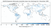
River discharge
Volumetric soil moisture
Snow water equivalent
Soil wetness index (root zone)
Runoff water equivalent (surface plus subsurface)
Interval/period: Wed, 10/14/2020 - Sat, 07/04/2026
Interval/period: Sun, 01/03/1999 - Sat, 11/25/2023

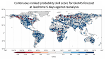
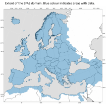
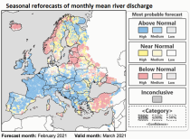
This dataset provides gridded modelled hydrological time series forced with medium-range meteorological forecasts. The data is a consistent representation of the most important hydrological variables across the European Flood Awareness System (EFAS) domain. The temporal resolution is sub-daily high-resolution and ensemble forecasts of:
River discharge
Soil moisture for three soil layers
Snow water equivalent
Interval/period: N/A
River discharge
Volumetric soil moisture
Snow water equivalent
Soil wetness index (root zone)
Runoff water equivalent (surface plus subsurface)
Interval/period: Fri, 01/01/1999 - Sat, 07/04/2026
Interval/period: Thu, 01/01/1981 - Sat, 07/01/2023
The height of topography above mean sea level and the depth of the sea for each model grid box ...
Interval/period: N/A

Interval/period: Tue, 10/01/1985 - Wed, 12/31/2025

Interval/period: Sun, 09/01/1985 - Wed, 12/31/2025
Interval/period: Sun, 01/01/1950 - Fri, 01/01/2100
Interval/period: Fri, 01/01/2021 - Sat, 07/04/2026
Soil moisture handling in the model is complex, and could be highlighted in many ways. Here a 'relativistic' approach is used for display, showing not absolute values, but instead...
Interval/period: N/A

Interval/period: Sun, 01/01/1950 - Thu, 06/25/2026

Interval/period: Sun, 01/01/1950 - Fri, 05/01/2026