Datasets

Interval/period: Wed, 01/01/1992 - Sat, 01/01/2022

Interval/period: Thu, 06/01/1995 - Tue, 12/31/2024

Interval/period: Tue, 09/01/1981 - Sun, 12/01/2024
Interval/period: Mon, 01/01/2001 - Fri, 04/01/2022

Interval/period: N/A
Interval/period: Wed, 01/03/1940 - Tue, 05/05/2026
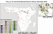
Fire radiative power and active fire pixels from 2020 to present derived from satellite observations

Interval/period: Wed, 01/01/2020 - Fri, 02/28/2025

Interval/period: Mon, 01/01/1951 - Sat, 05/09/2026
Interval/period: Mon, 01/01/1979 - Thu, 04/30/2026

This dataset provides aerosol optical depths and aerosol-radiation radiative effects for four different aerosol origins: anthropogenic, mineral dust, marine, and land-based fine-mode natural aerosol. The latter mostly consists of biogenic aerosols.
Interval/period: N/A

This dataset provides geographical distributions of the radiative forcing (RF) by key atmospheric constituents. The radiative forcing estimates are based on the CAMS reanalysis and additional model simulations and are provided separately for...
- carbon dioxide
- methane
- tropospheric ozone
- stratospheric ozone
- interactions between anthropogenic aerosols and radiation
Interval/period: N/A

The CAMS solar radiation services provide historical values (2004 to present) of global (GHI), direct (BHI) and diffuse (DHI) solar irradiation, as well as direct normal irradiation (BNI). The aim is to fulfil the needs of European and national policy development and the requirements of both commercial and public downstream services, e.g. for planning, monitoring, efficiency improvements and the integration of solar energy systems into energy supply grids.
Interval/period: N/A

Interval/period: N/A

Interval/period: Mon, 01/01/1940 - Fri, 12/31/2100

Interval/period: N/A
Interval/period: Sun, 01/01/1950 - Thu, 12/31/2099
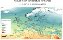
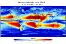
Interval/period: Mon, 01/01/1979 - Mon, 12/31/2018

Fifth Generation of the European Centre for Medium-Range Weather Forecasts (ECMWF) Reanalysis (ERA5).
Produced by replaying only the land component of the ECMWF ERA5 climate reanalysis, it benefits from the same physical data-assimilation framework but runs offline at
higher spatial detail (9 km grid) to deliver richer land-surface information.
Interval/period: Sun, 01/01/1950 - Thu, 12/31/2026

Interval/period: Sun, 01/01/1950 - Sat, 05/02/2026

Interval/period: Sun, 01/01/1950 - Wed, 04/01/2026

Interval/period: Sun, 01/01/1950 - Sat, 05/02/2026
Interval/period: Sun, 01/01/1950 - Thu, 12/31/2099
Interval/period: Mon, 01/01/1979 - Mon, 12/31/2018
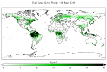
The two main variable groups are fuel load and fuel moisture, both of which are further divided by live/dead and wood/foliage fractions.
The dataset combines state-of-the-art model data (ERA5-Land) with observations from multiple satellites and in-situ variables into a globally complete and consistent dataset.
Interval/period: Wed, 01/01/2003 - Fri, 12/31/2021
Interval/period: Sun, 02/01/1981 - Wed, 04/01/2026