Datasets

Interval/period: Wed, 01/01/1992 - Sat, 01/01/2022

Interval/period: Thu, 06/01/1995 - Tue, 12/31/2024

Interval/period: Tue, 09/01/1981 - Sun, 12/01/2024

ECMWF is now running a series of data-driven forecasts as part of its experimental suite. These machine-learning based models are very fast, and they produce a 10-day forecast with 6-hourly time steps in approximately one minute. The outputs are available in graphical form.
Currently, three of these models are available:
Interval/period: N/A
Interval/period: Mon, 01/01/2001 - Fri, 04/01/2022

Interval/period: N/A
Interval/period: Wed, 01/03/1940 - Tue, 05/05/2026
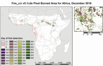
Fire radiative power and active fire pixels from 2020 to present derived from satellite observations

Interval/period: Wed, 01/01/2020 - Fri, 02/28/2025

Interval/period: Mon, 01/01/1951 - Sat, 05/09/2026
Interval/period: Mon, 01/01/1979 - Thu, 04/30/2026
ECMWF is now running its own Artificial Intelligence Forecasting System (AIFS). The AIFS consists of a deterministic model and an ensemble model. The deterministic model has been running operationally since 25 February 2025; further details can be found on the dedicated Implementation of AIFS Single v1 page.
Interval/period: N/A

Interval/period: N/A

Interval/period: Mon, 01/01/1940 - Fri, 12/31/2100

Interval/period: N/A
Interval/period: Sun, 01/01/1950 - Thu, 12/31/2099
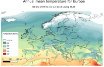
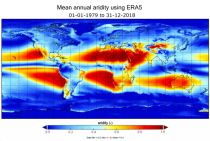
Interval/period: Mon, 01/01/1979 - Mon, 12/31/2018

Fifth Generation of the European Centre for Medium-Range Weather Forecasts (ECMWF) Reanalysis (ERA5).
Produced by replaying only the land component of the ECMWF ERA5 climate reanalysis, it benefits from the same physical data-assimilation framework but runs offline at
higher spatial detail (9 km grid) to deliver richer land-surface information.
Interval/period: Sun, 01/01/1950 - Thu, 12/31/2026

Interval/period: Sun, 01/01/1950 - Sat, 05/02/2026

Interval/period: Sun, 01/01/1950 - Wed, 04/01/2026

Interval/period: Sun, 01/01/1950 - Sat, 05/02/2026
Interval/period: Sun, 01/01/1950 - Thu, 12/31/2099
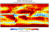
Interval/period: Mon, 01/01/1979 - Mon, 12/31/2018
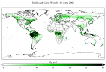
The two main variable groups are fuel load and fuel moisture, both of which are further divided by live/dead and wood/foliage fractions.
The dataset combines state-of-the-art model data (ERA5-Land) with observations from multiple satellites and in-situ variables into a globally complete and consistent dataset.
Interval/period: Wed, 01/01/2003 - Fri, 12/31/2021
Interval/period: Sun, 02/01/1981 - Wed, 04/01/2026
Interval/period: Tue, 09/01/1981 - Sun, 12/01/2024