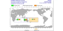
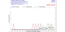
This chart provides information on the verification of forecasts of Accumulated Cyclone Energy ...

calendar_today Interval/period: N/A

open_in_newview in Open Charts

The ECMWF seasonal forecasts (SEAS5) are produced every month with a 51-member ensemble at a ...

calendar_today Interval/period: N/A

open_in_newview in Open Charts

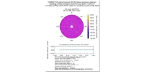
The idea of the plot is to be able to display each spectral partition as an arrow, with the direction being the mean direction, the length of the arrow the significant wave height, the colour of the arrow the mean wave period with the different arrow head for each partitions.

calendar_today Interval/period: N/A

open_in_newview in Open Charts

**These are experimental products and subject to change based on user feedback** These ...

calendar_today Interval/period: N/A

open_in_newview in Open Charts

This chart shows the probability that both the wind at 10 m above the earth's surface is ...

calendar_today Interval/period: N/A

open_in_newview in Open Charts
This dataset provides daily and monthly fields of global sea surface temperature (SST) and sea ice surface temperature (IST) from 1982 to the present, using observations from multiple infrared and passive microwave satellite sensors. SST is a key driver of global weather and climate, affecting ocean-atmosphere interactions and driving climate variability.

calendar_today Interval/period: Fri, 01/01/1982 - Tue, 12/31/2024

Significant wave height can be shown to correspond to the average wave height of the top one-third highest waves. The wave period of windsea is generally <10s,...

calendar_today Interval/period: N/A

open_in_newview in Open Charts

This chart shows probability information regarding mean wave period derived from the ECMWF ...

calendar_today Interval/period: N/A

open_in_newview in Open Charts

This chart shows probability information regarding significant wave height derived from the ...

calendar_today Interval/period: N/A

open_in_newview in Open Charts

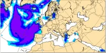
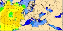
These charts show the probability of various mean periods of ocean waves 10-15 days ahead. The ...

calendar_today Interval/period: N/A

open_in_newview in Open Charts

These charts show probability of various heights of significant waves 10-15 days ahead. The ...

calendar_today Interval/period: N/A

open_in_newview in Open Charts

Significant wave height can be shown to correspond to the average wave height of the top one-third highest waves. The wave period of windsea is generally <10s,...

calendar_today Interval/period: N/A

open_in_newview in Open Charts

Mean wave period is the spectrally averaged period of the waves. Wave periods are shown in seconds using colour shading – click on the middle icon to the bottom right for the scale...

calendar_today Interval/period: N/A

open_in_newview in Open Charts
This dataset provides statistical indicators of tides, storm surges and sea level that can be used to characterize global sea level in present-day conditions and also to assess changes under climate change. The indicators calculated include extreme-value indicators (e.g. return periods including confidence bounds for total water levels and surge levels), probability indicators (e.g. percentile for total water levels and surge levels).

calendar_today 
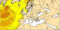
Interval/period: Mon, 01/01/1951 - Sat, 12/31/2050

This dataset provides time series of global sea level related variables including tides, storm surges and sea level rise from 1950 to 2050 based on hydrodynamic modelling. The dataset provides a basis for studies, for instance, aiming to evaluate sea level variability, coastal flooding, coastal erosion, and accessibility of ports.

calendar_today 
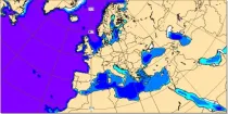
Interval/period: Sun, 01/01/1950 - Sat, 12/31/2050

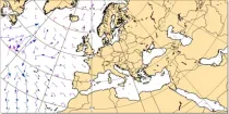
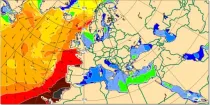
These charts show areas where anomalous significant wave heights are likely to occur. These charts are based on the ECMWF ense ...

calendar_today Interval/period: N/A

open_in_newview in Open Charts
This dataset provides daily gridded data of sea ice concentration for both hemispheres derived from satellite passive microwave brightness temperatures. Sea ice is an important component of our climate system and a sensitive indicator of climate change. Its presence or its retreat has a strong impact on air-sea interactions, the Earth’s energy budget as well as marine ecosystems. It is recognised by the Global Climate Observing System as an Essential Climate Variable.

calendar_today 
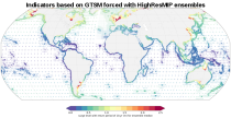
Interval/period: Sun, 10/01/1978 - Mon, 09/29/2025

This dataset provides daily gridded fields of sea ice drift vectors for both hemispheres derived from satellite passive microwave brightness temperatures and atmospheric reanalysis data. Sea ice is an important component of our climate system and a sensitive indicator of climate change. Its presence or retreat significantly affects ocean-atmosphere interactions, the Earth’s energy budget as well as marine ecosystems. It is classified as an Essential Climate Variable by the Global Climate Observing System.

calendar_today Interval/period: Tue, 01/01/1991 - Thu, 12/31/2020

This dataset provides daily gridded data of sea ice edge and sea ice type derived from brightness temperatures measured by satellite passive microwave radiometers. Sea ice is an important component of our climate system and a sensitive indicator of climate change. Its presence or its retreat has a strong impact on air-sea interactions, the Earth’s energy budget as well as marine ecosystems. It is recognized by the Global Climate Observing System as an Essential Climate Variable. Sea ice edge and type are some of the parameters used to characterise sea ice.

calendar_today 
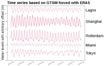
Interval/period: Wed, 10/25/1978 - Wed, 09/24/2025

This dataset provides daily and monthly sea ice surface temperature (IST) fields over the polar oceans from 1982 to the present. The data are derived from thermal infrared measurements from a single satellite sensor type: the Advanced Very High Resolution Radiometer (AVHRR) onboard National Oceanic and Atmospheric Administration (NOAA) and Meteorological Operational (MetOp) satellites.

calendar_today Interval/period: Mon, 01/01/1979 - Tue, 09/30/2025

This dataset provides global daily sea surface temperature (SST) data from the Group for High Resolution Sea Surface Temperature (GHRSST) multi-product ensemble (GMPE) produced by the European Space Agency SST Climate Change Initiative (ESA SST CCI). The GMPE system was designed to allow users to compare the outputs from different SST analysis systems and understand their similarities and differences. Although originally intended for comparison of near real time data, it has also been used to compare long historical datasets.

calendar_today Interval/period: Tue, 09/01/1981 - Sat, 12/31/2016

The ECMWF seasonal forecasts (SEAS5) are produced every month with a 51-member ensemble at a ...

calendar_today Interval/period: N/A

open_in_newview in Open Charts

This chart provides information on the verification of forecasts of the number of tropical ...

calendar_today Interval/period: N/A

open_in_newview in Open Charts

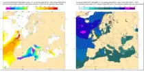
Mean total swell wave direction is the spectrally averaged propagation direction of the swell waves (weighted by wave height) of the part of the spectrum that is NOT windsea...

calendar_today Interval/period: N/A

open_in_newview in Open Charts

Wave height is the vertical distance between trough and crest. Wave period is the time between the passage of one wave crest and the next. The arrow direction is the direction the waves are moving towards...

calendar_today Interval/period: N/A

open_in_newview in Open Charts