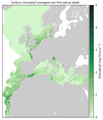
Atmospheric Model high resolution 15-day forecast (HRES)

Single prediction that uses

observations prior information about the Earth-system ECMWF's highest-resolution model

HRES Direct model output Products offers "High Frequency products"  

calendar_today Interval/period: N/A

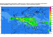
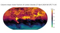
This data set contains net fluxes at the surface, atmospheric mixing ratios at model levels, for carbon dioxide (CO2), methane (CH4) and nitrous oxide (N20).

calendar_today Interval/period: N/A

The dataset contains model projections of changes in marine physics and biogeochemistry and the lower trophic levels of the marine food web across the Northwest European Shelf and Mediterranean Sea out to the year 2100.

calendar_today Interval/period: Mon, 01/01/1979 - Mon, 12/31/2018

This dataset contains 4 Essential Climate Variables (ECV) for the 18 bias adjusted Global Climate Models (GCM) from CMIP5: daily precipitation rate, and daily mean, maximum and minimum temperatures.
The data are bias adjusted using the Distribution Based Scaling (DBS) method versus the global reference dataset HydroGFD2.0, both bias adjustment method and global reference dataset developed by the Swedish Meteorological and Hydrological Institute (SMHI).
The DBS method is a parametric quantile-mapping variant.

calendar_today Interval/period: Thu, 10/12/2000 - Thu, 10/18/2018

15-member coupled IFS (cycle 43R1) extended-range reforecast experiment covering the period 1989-2015. The atmosphere is configured with 91 vertical levels and uses the Tco399 cubic octahedral reduced Gaussian grid. The IFS is coupled hourly to the 75 level version of the NEMO v3.4 ocean model and the LIM2 sea-ice model, both of which use the ORCA025 tripolar grid. Coupling follows the implementation used in ECMWF operational forecasts.

calendar_today Interval/period: N/A

15-member coupled IFS (cycle 43R1) extended-range reforecast experiment covering the period 1989-2015 with bias-corrected sea-surface temperatures (SSTs) in the North Atlantic region. This experiment can be compared with gkzp, which is the relevant control without bias-correction. The atmosphere is configured with 91 vertical levels and uses the Tco399 cubic octahedral reduced Gaussian grid.

calendar_today Interval/period: N/A

The dataset presents projections of fire danger indicators for Europe based upon the Canadian Fire Weather Index System (FWI) under future climate conditions. The FWI is a meteorologically based index used worldwide to estimate the fire danger and is implemented in the Global ECMWF Fire Forecasting model (GEFF). In this dataset, daily FWI values, seasonal FWI values, and other FWI derived, threshold-specific, indicators were modelled using the GEFF model to estimate the fire danger in future climate scenarios.

calendar_today Interval/period: N/A

This dataset provides agroclimatic indicators used to characterise plant-climate interactions for global agriculture. Agroclimatic indicators are useful in conveying climate variability and change in the terms that are meaningful to the agricultural sector. The objective of this dataset is to provide these indicators at a global scale in an easily accessible and usable format for further downstream analysis and the forcing of agricultural impact models.

calendar_today Interval/period: Mon, 01/01/1951 - Mon, 05/11/2026

The Sub-seasonal To Seasonal dataset (S2S) consists of global ensemble real-time forecasts and reforecasts from thirteen numerical weather prediction (NWP) and research centres.
S2S project behind the dataset started in 2013 as a joint initiative of the World Weather Research Programme (WWRP) and the World Climate Research Programme (WCRP).
The goal of S2S project was to improve sub-seasonal forecast skill through combining multiple forecasting systems, enable multi-model evaluations and enhance knowledge sharing between operational centres.

calendar_today Interval/period: Thu, 01/01/2015 - Wed, 05/06/2026

The Sub-seasonal To Seasonal dataset (S2S) consists of global ensemble real-time forecasts and reforecasts from thirteen numerical weather prediction (NWP) and research centres.
S2S project behind the dataset started in 2013 as a joint initiative of the World Weather Research Programme (WWRP) and the World Climate Research Programme (WCRP).
The goal of S2S project was to improve sub-seasonal forecast skill through combining multiple forecasting systems, enable multi-model evaluations and enhance knowledge sharing between operational centres.

calendar_today Interval/period: Tue, 03/01/2011 - Tue, 06/09/2026

This dataset provides daily air quality analyses and forecasts for Europe.
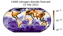
CAMS produces specific daily air quality analyses and forecasts for the European
domain at significantly higher spatial resolution (0.1 degrees, approx. 10km)
than is available from the global analyses and forecasts. The production is
based on an ensemble of eleven air quality forecasting systems across Europe. A
median ensemble is calculated from individual outputs, since ensemble products

calendar_today Interval/period: Wed, 05/03/2023 - Fri, 05/08/2026

This dataset provides daily air quality forecasts at European observation
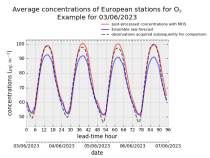
stations after optimisation using a statistical post-processing method called
Model Output Statistics (MOS). The unoptimised "raw" forecasts are also
provided in the same format.
The MOS method uses machine learning with predictive variables including
background air quality observation datasets, ECMWF meteorological forecasts and
the "raw" CAMS European air quality ensemble median forecast. The result is

calendar_today Interval/period: Wed, 01/17/2024 - Fri, 05/08/2026

CAMS produces global forecasts for atmospheric composition twice a day. The forecasts consist of more than 50 chemical species (e.g. ozone, nitrogen dioxide, carbon monoxide) and seven different types of aerosol (desert dust, sea salt, organic matter, black carbon, sulphate, nitrate and ammonium aerosol). In addition, several meteorological variables are available as well.

calendar_today Interval/period: Thu, 01/01/2015 - Thu, 05/07/2026

CAMS produces global forecasts for the two main long-lived greenhouse gases once a day. This dataset consists of 5-day high-resolution forecasts of carbon dioxide (CO2) and methane (CH4). Additionally, carbon monoxide (CO) and meteorological parameters relevant to the CAMS greenhouse gas forecast are included.

calendar_today Interval/period: Fri, 03/01/2024 - Thu, 05/07/2026

This dataset provides climate and energy indicators for the Europe as part of the Copernicus climate change service (C3S) Energy operational service. The climate-relevant indicators for the energy sector considered are: air temperature, precipitation, incoming solar radiation, wind speed at 10 m and 100 m, and mean sea level air pressure. The energy indicators are electricity demand and power generation from various sources: wind (both onshore and offshore), solar and hydro (run-of-river and reservoir) power.

calendar_today Interval/period: N/A

The Pan-European Climate Database (PECD) provides information on climate and renewable energy variables for both historical and future time periods. For historical data, the ERA5 global reanalysis serves as the underlying climate data, while future projections are based on selected CMIP6 global climate models. The raw climate model data are further processed through downscaling to achieve higher spatial and temporal resolution and by applying bias adjustment.

calendar_today Interval/period: Sun, 01/01/1950 - Wed, 12/01/2100

The dataset provides climate extreme indices related to temperature and precipitation as defined by the Expert Team on Climate Change Detection and Indices (ETCCDI), as well as selected heat stress indicators (HSI). The indices are provided for historical and future climate projections (SSP1-2.6, SSP2-4.5, SSP3-7.0, SSP5-8.5) included in the Coupled Model Intercomparison Project Phase 6 (CMIP6) and used in the 6th Assessment Report of the Intergovernmental Panel on Climate Change (IPCC).

calendar_today Interval/period: N/A

This dataset provides a series of climate indices derived from reanalysis and model simulations data hosted on the Copernicus Climate Data Store (CDS). These indicators describe how climate variability and change of essential climate variables can impact sectors such as health, agriculture, forestry, energy, tourism, or water and coastal management.

calendar_today Interval/period: Mon, 01/01/1940 - Fri, 12/31/2100

This dataset contains climatic suitability indicators for the Aedes albopictus (tiger mosquito) for Europe produced within the C3S European Health service. The provided indicators are the climatic suitability for the presence of Aedes albopictus and the season length of presence of Aedes albopictus. This mosquito transmits vector-borne diseases, such as dengue and chikungunya.

calendar_today Interval/period: N/A

This catalogue entry provides daily climate projections on pressure levels from a large number of experiments, models, members and time periods computed in the framework of fifth phase of the Coupled Model Intercomparison Project (CMIP5). The term "pressure levels" is used to express that the variables were computed at multiple vertical levels, which may differ in number and location among the different models.

calendar_today Interval/period: Sun, 01/01/1860 - Mon, 12/31/2300

This catalogue entry provides daily climate projections on single levels from a large number of experiments, models, members and time periods computed in the framework of the fifth phase of the Coupled Model Intercomparison Project (CMIP5). The term "single levels" is used to express that the variables are computed at one vertical level which can be surface (or a level close to the surface) or a dedicated pressure level in the atmosphere. Multiple vertical levels are excluded from this catalogue entry.

calendar_today Interval/period: Wed, 01/01/1800 - Fri, 12/31/2100

This catalogue entry provides monthly climate projections on pressure levels from a large number of experiments, models, members and time periods computed in the framework of the fifth phase of the Coupled Model Intercomparison Project (CMIP5). The term "pressure levels" is used to express that the variables were computed at multiple vertical levels, which may differ in number and location among the different models.

calendar_today Interval/period: Sun, 01/01/1860 - Mon, 12/31/2300

This catalogue entry provides monthly climate projections on single levels from a large number of experiments, models, members and time periods computed in the framework of fifth phase of the Coupled Model Intercomparison Project (CMIP5). The term "single levels" is used to express that the variables are computed at one vertical level which can be surface (or a level close to the surface) or a dedicated pressure level in the atmosphere. Multiple vertical levels are excluded from this catalogue entry.

calendar_today Interval/period: Sun, 01/01/1860 - Mon, 12/31/2300

This catalogue entry provides daily and monthly global climate projections data from a large number of experiments, models and time periods computed in the framework of the sixth phase of the Coupled Model Intercomparison Project (CMIP6).
CMIP6 data underpins the Intergovernmental Panel on Climate Change 6th Assessment Report. The use of these data is mostly aimed at:

addressing outstanding scientific questions that arose as part of the IPCC reporting process;
improving the understanding of the climate system;

calendar_today Interval/period: Sun, 01/01/1860 - Mon, 12/31/2300

This catalogue entry provides daily and monthly global climate model data from Decadal Climate Predictions Project (DCPP) experiments, part of the sixth phase of the Coupled Model Intercomparison Project (CMIP6). The decadal data in the Climate Data Store (CDS) are a quality-controlled subset of the full DCPP.

calendar_today Interval/period: Sun, 01/01/1860 - Mon, 12/31/2300