Datasets
Displaying 1 - 9 of 9

This dataset provides lake water levels for 311 selected lakes on four continents derived from satellite radar altimetry.
Interval/period: Wed, 01/01/1992 - Sat, 05/09/2026

The C3S Arctic Regional Reanalysis second generation (CARRA2) dataset contains daily and monthly meteorological variables at 2.5 km resolution. These variables are specified at single levels (including surface) and also at soil, height, pressure and model levels. These daily and monthly data are pre-calculated and have the following types depending on the variables: daily and monthly averages, extremes and totals.
Interval/period: Wed, 01/01/1986 - Sun, 12/31/2023

The C3S Arctic Regional Reanalysis second generation (CARRA2) dataset contains 3-hourly analyses at 2.5 km resolution. These variables are specified at single levels (including surface) and also at soil, height, pressure and model levels. Additionally, hourly forecasts are available between the analysis times and particularly forecasts up to 18 hours initialised from the analyses at 00 and 12 UTC.
Interval/period: Wed, 01/01/1986 - Sun, 12/31/2023

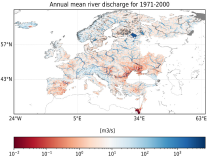
This dataset provides gridded modelled hydrological time series forced with medium- to sub-seasonal range meteorological reforecasts. The data is a consistent representation of the most important hydrological variables across the European Flood Awareness System (EFAS) domain. The temporal resolution is 20 years of sub-daily reforecasts initialised twice weekly (Mondays and Thursdays) of:
River discharge
Volumetric soil moisture
Snow water equivalent
Soil wetness index (root zone)
Runoff water equivalent (surface plus subsurface)
River discharge
Volumetric soil moisture
Snow water equivalent
Soil wetness index (root zone)
Runoff water equivalent (surface plus subsurface)
Interval/period: Wed, 10/14/2020 - Sat, 05/09/2026

The daily and monthly data of the C3S Arctic Regional Reanalysis (CARRA) dataset contains daily and monthly meteorological variables at 2.5 km resolution. This includes fields at the single levels (including surface) and on pressure, height, soil and model levels.
These daily and monthly data are pre-calculated and have the following types depending on the variables: daily and monthly averages, extremes and totals.
These daily and monthly data are pre-calculated and have the following types depending on the variables: daily and monthly averages, extremes and totals.
Interval/period: Sat, 09/01/1990 - Sat, 02/28/2026
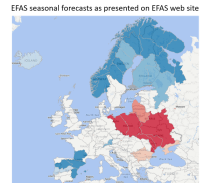
This dataset provides hydrological seasonal forecasts of monthly mean river discharge across Europe. Two hydrological model ensembles are provided. The first is an E-HYPE multi-model system comprising eight model realisations using a catchment-based resolution. The second comprises the E-HYPEgrid, VIC-WUR and EFAS (LISFLOOD) hydrological models at a 5km gridded resolution.
Interval/period: Tue, 12/01/2020 - Wed, 04/01/2026
This dataset provides gridded modelled daily hydrological time series forced with seasonal meteorological forecasts. The dataset is a consistent representation of the most important hydrological variables across the European Flood Awareness (EFAS) domain. The temporal resolution is daily forecasts initialised once a month consisting of:
River discharge
Volumetric soil moisture
Snow water equivalent
Soil wetness index (root zone)
Runoff water equivalent (surface plus subsurface)
River discharge
Volumetric soil moisture
Snow water equivalent
Soil wetness index (root zone)
Runoff water equivalent (surface plus subsurface)
Interval/period: Sun, 11/01/2020 - Wed, 04/01/2026
This dataset provides an ensemble of forecasted time series of gridded hydrological data forced with seasonal meteorological forecasts. The data set is a product of the Global Flood Awareness System (GloFAS) and offers a consistent representation of key hydrological variables across the global domain including:
River discharge
Soil wetness index (root zone)
Snow water equivalent
Runoff water equivalent (surface plus subsurface)
River discharge
Soil wetness index (root zone)
Snow water equivalent
Runoff water equivalent (surface plus subsurface)
Interval/period: Tue, 12/01/2020 - Wed, 04/01/2026
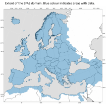
This dataset provides modelled daily hydrological time series forced with seasonal meteorological reforecasts. The dataset is a consistent representation of the most important hydrological variables across the European Flood Awareness (EFAS) domain. The temporal resolution is daily forecasts initialised once a month from 1991 to near real-time of:
River discharge
Volumetric soil moisture
Snow water equivalent
Soil wetness index (root zone)
Runoff water equivalent (surface plus subsurface)
River discharge
Volumetric soil moisture
Snow water equivalent
Soil wetness index (root zone)
Runoff water equivalent (surface plus subsurface)
Interval/period: Fri, 01/01/1999 - Sat, 05/09/2026