Datasets

Interval/period: N/A
Fire radiative power and active fire pixels from 2020 to present derived from satellite observations

Interval/period: Wed, 01/01/2020 - Fri, 02/28/2025
Interval/period: Thu, 04/04/2002 - Tue, 04/01/2025
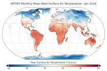
Interval/period: Mon, 01/01/1940 - Fri, 05/09/2025
Interval/period: Thu, 10/18/2018 - Wed, 07/31/2019
It has been generated using the UERRA-HARMONIE system by combining model data with observations into a complete and consistent dataset using the laws of physics.
Interval/period: Thu, 10/18/2018 - Wed, 07/31/2019
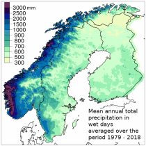
UERRA-HARMONIE and MESCAN-SURFEX systems. Forecasts up to 30 hours initialised
from the analyses at 00 and 12 UTC are available only through the CDS-API (see Documentation).
UERRA-HARMONIE is a 3-dimensional variational data assimilation system,
while MESCAN-SURFEX is a complementary surface analysis system.
Using the Optimal Interpolation method, MESCAN provides the best estimate of daily accumulated precipitation
Interval/period: Thu, 10/18/2018 - Wed, 07/31/2019

combined with observations using the UERRA-HARMONIE system and MESCAN-SURFEX system.
UERRA-HARMONIE is a 3-dimensional data assimilation system, whereas
MESCAN-SURFEX is a complementary surface analysis system. In general, the
assimilation systems are able to estimate biases between observations and to
sift good-quality data from poor data. The laws of physics allow for estimates
Interval/period: Thu, 10/18/2018 - Wed, 07/31/2019
Interval/period: Tue, 07/05/1994 - Sun, 02/28/2021
Interval/period: Sun, 01/03/1999 - Sat, 11/25/2023
Interval/period: Thu, 01/01/1981 - Sat, 07/01/2023
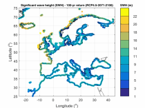
Interval/period: Thu, 01/01/1976 - Fri, 12/31/2100
Interval/period: Thu, 01/01/1976 - Fri, 12/31/2100
Interval/period: Wed, 01/01/1958 - Wed, 01/01/2025
Interval/period: Wed, 04/01/1970 - Tue, 07/01/2025

Interval/period: Tue, 10/01/1985 - Wed, 12/31/2025

Interval/period: Sun, 09/01/1985 - Wed, 12/31/2025
Interval/period: Tue, 10/01/2002 - Mon, 06/30/2025
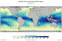
This catalogue entry provides the TCWV data product usually called Hamburg Ocean Atmosphere Parameters and Fluxes from Satellite Data (HOAPS).
Interval/period: Wed, 05/01/2002 - Thu, 03/01/2012
Interval/period: Sun, 01/01/1950 - Fri, 01/01/2100
Interval/period: Fri, 01/01/2021 - Sat, 07/04/2026
Interval/period: Mon, 01/01/1979 - Tue, 12/31/2024
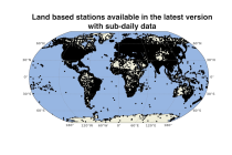
Spatial interpolation methods are applied to observational datasets to create gridded datasets.
In general, there are three types of such methods: deterministic (type 1), stochastic (type 2) and pure mathematical (type 3).
Interval/period: Sun, 01/01/1961 - Thu, 09/18/2025
Interval/period: Sun, 01/01/1978 - Wed, 10/17/2018
Interval/period: Mon, 01/01/2018 - Tue, 12/31/2024