Datasets
Displaying 1 - 3 of 3
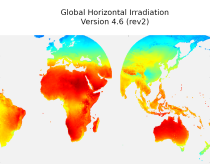
This dataset provides historical values of global, direct and diffuse solar
irradiation, as well as direct normal irradiation, on a latitude/longitude grid
covering land surfaces and coastal areas of Europe, Africa, Oceania, Eastern
South America, the Middle East and South-East Asia. It is created from 15 minute
resolved timeseries at each grid point. These timeseries were calculated by the
CAMS Solar Radiation Time Series Service and use information on aerosol, ozone
Interval/period: Sat, 01/01/2005 - Sun, 12/31/2023
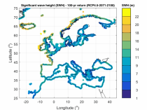
The dataset presents wave climate indicators based upon ocean surface wave parameters computed for a European-wide domain. This dataset provides an understanding of the European wave climate under the impact of climate change. It provides added value for various coastal sectors and studies such as port, shipping, and coastal management.
Interval/period: Thu, 01/01/1976 - Fri, 12/31/2100
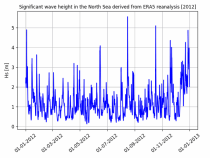
The dataset presents time series of the coastal wave climate based upon ocean surface wave parameters computed for a European-wide domain. This dataset provides an understanding of the wave climate under the impact of climate change for the Northwest European Shelf and Mediterranean Sea. It provides added value for various coastal sectors and studies such as port, shipping, and coastal management.
Interval/period: Thu, 01/01/1976 - Fri, 12/31/2100