Datasets
Displaying 1 - 8 of 8

The dataset presents projections of fire danger indicators for Europe based upon the Canadian Fire Weather Index System (FWI) under future climate conditions. The FWI is a meteorologically based index used worldwide to estimate the fire danger and is implemented in the Global ECMWF Fire Forecasting model (GEFF). In this dataset, daily FWI values, seasonal FWI values, and other FWI derived, threshold-specific, indicators were modelled using the GEFF model to estimate the fire danger in future climate scenarios.
Interval/period: N/A
The present UERRA dataset contains analyses of atmospheric variables on height levels, from 1961 to 2019.
Interval/period: Thu, 10/18/2018 - Wed, 07/31/2019
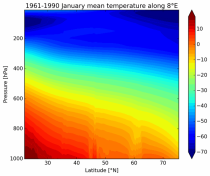
The present UERRA dataset contains analyses of atmospheric variables on pressure levels, from 1961 to 2019.
It has been generated using the UERRA-HARMONIE system by combining model data with observations into a complete and consistent dataset using the laws of physics.
It has been generated using the UERRA-HARMONIE system by combining model data with observations into a complete and consistent dataset using the laws of physics.
Interval/period: Thu, 10/18/2018 - Wed, 07/31/2019
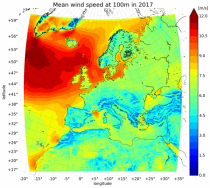
This UERRA dataset contains analyses of surface and near-surface essential climate variables from
UERRA-HARMONIE and MESCAN-SURFEX systems. Forecasts up to 30 hours initialised
from the analyses at 00 and 12 UTC are available only through the CDS-API (see Documentation).
UERRA-HARMONIE is a 3-dimensional variational data assimilation system,
while MESCAN-SURFEX is a complementary surface analysis system.
Using the Optimal Interpolation method, MESCAN provides the best estimate of daily accumulated precipitation
Interval/period: Thu, 10/18/2018 - Wed, 07/31/2019

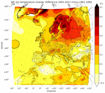
This dataset provides a series of climate indices derived from reanalysis and model simulations data hosted on the Copernicus Climate Data Store (CDS). These indicators describe how climate variability and change of essential climate variables can impact sectors such as health, agriculture, forestry, energy, tourism, or water and coastal management.
Interval/period: Mon, 01/01/1940 - Fri, 12/31/2100

This dataset contains climatic suitability indicators for the Aedes albopictus (tiger mosquito) for Europe produced within the C3S European Health service. The provided indicators are the climatic suitability for the presence of Aedes albopictus and the season length of presence of Aedes albopictus. This mosquito transmits vector-borne diseases, such as dengue and chikungunya.
Interval/period: N/A
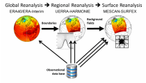
The UERRA datasets contain reanalysis data of the atmosphere, the surface and near-surface as well as for the soil covering Europe. Essential climate variables are generated with the UERRA-HARMONIE and the MESCAN-SURFEX systems. UERRA-HARMONIE is a 3-dimensional variational data assimilation system, while MESCAN-SURFEX is a complementary surface analysis system.
Interval/period: Thu, 10/18/2018 - Wed, 07/31/2019

This catalogue entry provides Regional Climate Model (RCM) data on single levels from a number of experiments, models, domains, resolutions, ensemble members, time frequencies and periods computed over several regional domains all over the World in the framework of the Coordinated Regional Climate Downscaling Experiment (CORDEX). The term "single levels" is used to express that the variables are 2D-matrices computed on one vertical level which can be surface (or a level close to the surface) or a dedicated pressure level in the atmosphere.
Interval/period: Sun, 01/01/1950 - Fri, 12/31/2100