Datasets
Displaying 101 - 112 of 112
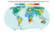
This dataset offers modeled daily fire danger time series, driven by seasonal weather forecasts. It provides long-range predictions of meteorological conditions conducive to the initiation, spread, and persistence of fires. The fire danger metrics included in this dataset are part of an extensive dataset produced by the Copernicus Emergency Management Service (CEMS) for the European Forest Fire Information System (EFFIS) and the Global Wildfire Information System (GWIS).
Interval/period: Sun, 02/01/1981 - Wed, 04/01/2026
This entry covers pressure-level data at the original time resolution (once every 12 hours).
Interval/period: Thu, 01/01/1981 - Fri, 05/01/2026
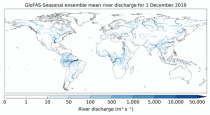
This dataset provides an ensemble of forecasted time series of gridded hydrological data forced with seasonal meteorological forecasts. The data set is a product of the Global Flood Awareness System (GloFAS) and offers a consistent representation of key hydrological variables across the global domain including:
River discharge
Soil wetness index (root zone)
Snow water equivalent
Runoff water equivalent (surface plus subsurface)
River discharge
Soil wetness index (root zone)
Snow water equivalent
Runoff water equivalent (surface plus subsurface)
Interval/period: Tue, 12/01/2020 - Wed, 04/01/2026
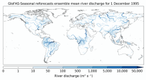
This dataset provides a gridded modelled time series of river discharge forced with seasonal range meteorological reforecasts. The data is a consistent representation of a key hydrological variable across the global domain, and is a product of the Global Flood Awareness System (GloFAS). It is accompanied by an ancillary file for interpretation that provides the upstream area (see the related variables table and associated link in the documentation).
Interval/period: Thu, 01/01/1981 - Sat, 07/01/2023
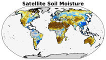
The C3S satellite soil moisture (SM) service provides a range of global soil moisture variables derived from numerous satellite sensors, including scatterometers and radiometers. The products are designed primarily for applications related to climate variability and change, land–atmosphere interactions, global biogeochemical cycles, ecology, hydrological and land surface modelling, drought monitoring, and meteorology.
Interval/period: Wed, 11/01/1978 - Mon, 04/20/2026
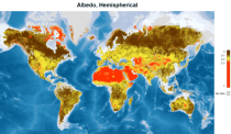
This catalogue entry provides satellite-derived estimates of surface albedo, an Essential Climate Variable (ECV) as defined by the Global Climate Observing System (GCOS). Surface albedo is critical for understanding the Earth’s climate, its variability, and trends, as it quantifies the fraction of solar irradiance reflected by the Earth’s surface. This variable plays a vital role in the global radiation budget, influencing surface temperatures, water balance, and climate feedback mechanisms, such as the ice-albedo feedback in polar regions.
Interval/period: Tue, 09/01/1981 - Sun, 12/01/2024
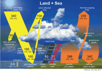
The Surface Radiation Budget (SRB) represents the balance between the heating of the Earth’s surface through absorption of incoming solar radiation and cooling through the emission of infra-red radiation, which is a fundamental component of the surface energy budget. Small changes in the surface radiation budget can lead to large climatological responses, which makes a permanent and precise monitoring indispensable.
Interval/period: Mon, 01/01/1979 - Mon, 06/30/2025
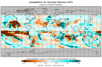
This dataset provides high-resolution gridded temperature and precipitation observations from a selection of sources. Additionally the dataset contains daily global average near-surface temperature anomalies. All fields are defined on either daily or monthly frequency. The datasets are regularly updated to incorporate recent observations. The included data sources are commonly known as GISTEMP, Berkeley Earth, CPC and CPC-CONUS, CHIRPS, IMERG, CMORPH, GPCC and CRU, where the abbreviations are explained below.
Interval/period: Thu, 01/01/1750 - Fri, 01/01/2021
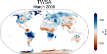
This dataset provides global Terrestrial Water Storage Anomalies (TWSA) on a 0.5° regular grid. TWSA represent deviations from the long-term average of water stored on or below the Earth’s surface in the form of soil moisture, groundwater, surface water, snow and ice. Designated as an Essential Climate Variable (ECV) as defined by the Global Climate Observing System (GCOS), TWSA is considered essential for contributing to a comprehensive view of Earth’s climate, its variability, and trends.
Interval/period: Thu, 04/04/2002 - Tue, 04/01/2025
This dataset provides a complete historical reconstruction for a set of indices representing human thermal stress and discomfort in outdoor conditions. This dataset, also known as ERA5-HEAT (Human thErmAl comforT) represents the current state-of-the-art for bioclimatology data record production.
The dataset is organised around two main variables:
the mean radiant temperature (MRT)
the universal thermal climate index (UTCI)
The dataset is organised around two main variables:
the mean radiant temperature (MRT)
the universal thermal climate index (UTCI)
Interval/period: Fri, 12/01/1939 - Sat, 05/02/2026
This catalogue entry provides a time series of thermal comfort indices, organised to make time the primary dimension for analysis and extraction. For any user-defined location (point) or small area, the dataset returns the temporal evolution of the selected variables, enabling efficient time-series studies without requiring users to download and manage full global gridded files.
Interval/period: Mon, 01/01/1940 - Fri, 05/09/2025
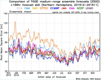
The International Grand Global Ensemble (TIGGE) dataset consists of global medium-range ensemble forecasts from thirteen numerical weather prediction (NWP) centres.
The dataset has been available since October 2006. TIGGE was established as a key component of THORPEX: a World Weather Research Programme to accelerate the improvements in the accuracy of 1-day to 2 week high-impact weather forecasts (THORPEX stands for THe Observing system Research and Predictability EXperiment)
The dataset has been available since October 2006. TIGGE was established as a key component of THORPEX: a World Weather Research Programme to accelerate the improvements in the accuracy of 1-day to 2 week high-impact weather forecasts (THORPEX stands for THe Observing system Research and Predictability EXperiment)
Interval/period: Sun, 10/01/2006 - Wed, 05/06/2026