The Global Climate Observing System (GCOS) Reference Upper-Air Network (GRUAN) is an international reference observing network, established in 2006, of sites measuring essential climate variables above Earth's surface, designed to fill an important gap in the current global observing system. GRUAN measurements are providing high-quality climate data records from the surface, through the troposphere, and into the stratosphere.

calendar_today Interval/period: Sun, 01/01/1978 - Wed, 10/17/2018

This dataset provides access to two types of ozone observations: total column ozone estimates and vertical profiles of ozone concentration.
The total ozone estimates are based on solar UV radiation measurements made by ground-based spectrophotometers (Dobson or Brewer type spectrophotometers).
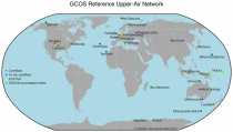
The vertical profiles of ozone concentration are estimated primarily using ozonesonde observations.
Data are available for 159 Dobson stations, 109 Brewer stations and 135 ozonesondes stations.

calendar_today Interval/period: Tue, 01/01/1924 - Sun, 05/10/2026

This dataset provides estimates of water vapour derived from atmospheric delays in Global Navigation Satellite System
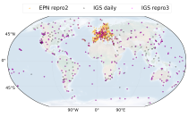
(GNSS) radio signals.
The initial data is collected from two in situ ground-based network of GNSS receivers – the International GNSS Service
(IGS) and EUREF Permanent Network (EPN). The IGS collects, archives, and freely distributes GNSS data from a
cooperatively operated global network of more than 500 ground-based GNSS stations since 1994. The EPN is a European

calendar_today Interval/period: Mon, 01/01/1996 - Sun, 05/10/2026

This catalogue entry provides access to vertical profiles of standard meteorological variables. It includes two archives.
The first is version 2 of the Integrated Global Radiosounding Archive (IGRA) from 1978 which incorporates global
radiosounding profiles of temperature, humidity and wind from a large number of data sources,
which is 30% larger than the previous version 1. IGRA v2 is the result of quality assurance procedures applied to the

calendar_today Interval/period: Sun, 01/01/1978 - Sun, 05/10/2026

This dataset provides monthly means of mass-consistent, vertically integrated, atmospheric energy and moisture budget quantities derived from 1-hourly ERA5 reanalysis data.
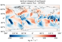
The vertically integrated budget diagnostics include the tendencies and lateral fluxes of total energy, water vapour, and latent heat (with the latent heat of vaporization varying with temperature). In addition, the divergences of the lateral fluxes are provided.

calendar_today Interval/period: Mon, 01/01/1979 - Sun, 05/10/2026

This dataset provides daily gridded data of sea ice concentration for both hemispheres derived from satellite passive microwave brightness temperatures. Sea ice is an important component of our climate system and a sensitive indicator of climate change. Its presence or its retreat has a strong impact on air-sea interactions, the Earth’s energy budget as well as marine ecosystems. It is recognised by the Global Climate Observing System as an Essential Climate Variable.

calendar_today Interval/period: Sun, 10/01/1978 - Mon, 09/29/2025

This dataset provides daily gridded fields of sea ice drift vectors for both hemispheres derived from satellite passive microwave brightness temperatures and atmospheric reanalysis data. Sea ice is an important component of our climate system and a sensitive indicator of climate change. Its presence or retreat significantly affects ocean-atmosphere interactions, the Earth’s energy budget as well as marine ecosystems. It is classified as an Essential Climate Variable by the Global Climate Observing System.

calendar_today Interval/period: Tue, 01/01/1991 - Thu, 12/31/2020

This dataset provides daily gridded data of sea ice edge and sea ice type derived from brightness temperatures measured by satellite passive microwave radiometers. Sea ice is an important component of our climate system and a sensitive indicator of climate change. Its presence or its retreat has a strong impact on air-sea interactions, the Earth’s energy budget as well as marine ecosystems. It is recognized by the Global Climate Observing System as an Essential Climate Variable. Sea ice edge and type are some of the parameters used to characterise sea ice.

calendar_today Interval/period: Wed, 10/25/1978 - Wed, 09/24/2025

This dataset provides daily and monthly sea ice surface temperature (IST) fields over the polar oceans from 1982 to the present. The data are derived from thermal infrared measurements from a single satellite sensor type: the Advanced Very High Resolution Radiometer (AVHRR) onboard National Oceanic and Atmospheric Administration (NOAA) and Meteorological Operational (MetOp) satellites.

calendar_today Interval/period: Mon, 01/01/1979 - Tue, 09/30/2025

This dataset provides gridded sea ice thickness data for the Arctic, derived from satellite observations. Sea ice plays a vital role in the climate system, influencing air-sea interactions, the Earth’s energy balance, and marine ecosystems. It is recognised by the Global Climate Observing System (GCOS) as an Essential Climate Variable (ECV). Sea ice thickness is a key characteristic used alongside other parameters such as concentration, edge, and type, all available in the Climate Data Store (CDS).

calendar_today Interval/period: Tue, 10/01/2002 - Sat, 04/12/2025

This dataset provides gridded daily and monthly mean global estimates of sea level anomaly based on satellite altimetry measurements. The rise in global mean sea level in recent decades has been one of the most important and well-known consequences of climate warming, putting a large fraction of the world population and economic infrastructure at greater risk of flooding. However, changes in the global average sea level mask regional variations that can be one order of magnitude larger.

calendar_today Interval/period: Fri, 01/01/1993 - Sun, 12/31/2023

This dataset provides global daily sea surface temperature (SST) data from the Group for High Resolution Sea Surface Temperature (GHRSST) multi-product ensemble (GMPE) produced by the European Space Agency SST Climate Change Initiative (ESA SST CCI). The GMPE system was designed to allow users to compare the outputs from different SST analysis systems and understand their similarities and differences. Although originally intended for comparison of near real time data, it has also been used to compare long historical datasets.

calendar_today Interval/period: Tue, 09/01/1981 - Sat, 12/31/2016

The Essential Climate Variables for assessment of climate variability from 1979 to present dataset contains a selection of climatologies, monthly anomalies and monthly mean fields of Essential Climate Variables (ECVs) suitable for monitoring and assessment of climate variability and change. Selection criteria are based on accuracy and temporal consistency on monthly to decadal time scales.

calendar_today Interval/period: Mon, 01/01/1979 - Wed, 04/01/2026

This dataset provides monthly and zonally averaged tropospheric humidity profiles derived from globally distributed GPS radio occultation (RO) measurements from EUMETSAT's Metop polar-orbiting satellites. Humidity plays an important role in the Earth's climate system, due to the strong greenhouse effect of water vapour but also for its role in the global energy transport, vertically in the atmosphere and horizontally between different geographical regions.

calendar_today Interval/period: Fri, 12/01/2006 - Mon, 12/01/2025

Upper Tropospheric Humidity (UTH) is of key importance to the Earth’s greenhouse effect and understanding of climate change. It is considered an Essential Climate Variable (ECV) because it controls key atmospheric processes, including those involved in water vapour and cloud feedbacks, that can amplify the climate system’s response to increases in other greenhouse gases. The Upper Tropospheric Humidity is defined as the integrated amount of Water Vapour in the atmospheric layer between ~500 hPa and ~200 hPa.

calendar_today Interval/period: Tue, 07/05/1994 - Sun, 02/28/2021

The Sub-seasonal To Seasonal dataset (S2S) consists of global ensemble real-time forecasts and reforecasts from thirteen numerical weather prediction (NWP) and research centres.
S2S project behind the dataset started in 2013 as a joint initiative of the World Weather Research Programme (WWRP) and the World Climate Research Programme (WCRP).
The goal of S2S project was to improve sub-seasonal forecast skill through combining multiple forecasting systems, enable multi-model evaluations and enhance knowledge sharing between operational centres.

calendar_today Interval/period: Thu, 01/01/2015 - Wed, 05/06/2026

The Sub-seasonal To Seasonal dataset (S2S) consists of global ensemble real-time forecasts and reforecasts from thirteen numerical weather prediction (NWP) and research centres.
S2S project behind the dataset started in 2013 as a joint initiative of the World Weather Research Programme (WWRP) and the World Climate Research Programme (WCRP).
The goal of S2S project was to improve sub-seasonal forecast skill through combining multiple forecasting systems, enable multi-model evaluations and enhance knowledge sharing between operational centres.

calendar_today Interval/period: Tue, 03/01/2011 - Tue, 06/09/2026

Cloud properties directly influence the state of the Earth´s upper-air atmosphere. Clouds have an effect on weather and climate through their contribution to the Earth’s water cycle and impact on the Earth’s energy budget. They impact atmospheric motions on a range of spatial and temporal scales and contribute to changes in the atmospheric composition.

calendar_today Interval/period: Mon, 01/01/1979 - Mon, 06/30/2025

This catalogue entry provides daily climate projections on pressure levels from a large number of experiments, models, members and time periods computed in the framework of fifth phase of the Coupled Model Intercomparison Project (CMIP5). The term "pressure levels" is used to express that the variables were computed at multiple vertical levels, which may differ in number and location among the different models.

calendar_today Interval/period: Sun, 01/01/1860 - Mon, 12/31/2300

This catalogue entry provides daily climate projections on single levels from a large number of experiments, models, members and time periods computed in the framework of the fifth phase of the Coupled Model Intercomparison Project (CMIP5). The term "single levels" is used to express that the variables are computed at one vertical level which can be surface (or a level close to the surface) or a dedicated pressure level in the atmosphere. Multiple vertical levels are excluded from this catalogue entry.

calendar_today Interval/period: Wed, 01/01/1800 - Fri, 12/31/2100

This catalogue entry provides monthly climate projections on pressure levels from a large number of experiments, models, members and time periods computed in the framework of the fifth phase of the Coupled Model Intercomparison Project (CMIP5). The term "pressure levels" is used to express that the variables were computed at multiple vertical levels, which may differ in number and location among the different models.

calendar_today Interval/period: Sun, 01/01/1860 - Mon, 12/31/2300

This catalogue entry provides monthly climate projections on single levels from a large number of experiments, models, members and time periods computed in the framework of fifth phase of the Coupled Model Intercomparison Project (CMIP5). The term "single levels" is used to express that the variables are computed at one vertical level which can be surface (or a level close to the surface) or a dedicated pressure level in the atmosphere. Multiple vertical levels are excluded from this catalogue entry.

calendar_today Interval/period: Sun, 01/01/1860 - Mon, 12/31/2300

This catalogue entry provides daily and monthly global climate projections data from a large number of experiments, models and time periods computed in the framework of the sixth phase of the Coupled Model Intercomparison Project (CMIP6).
CMIP6 data underpins the Intergovernmental Panel on Climate Change 6th Assessment Report. The use of these data is mostly aimed at:

addressing outstanding scientific questions that arose as part of the IPCC reporting process;
improving the understanding of the climate system;

calendar_today Interval/period: Sun, 01/01/1860 - Mon, 12/31/2300

This catalogue entry provides daily and monthly global climate model data from Decadal Climate Predictions Project (DCPP) experiments, part of the sixth phase of the Coupled Model Intercomparison Project (CMIP6). The decadal data in the Climate Data Store (CDS) are a quality-controlled subset of the full DCPP.

calendar_today Interval/period: Sun, 01/01/1860 - Mon, 12/31/2300

This dataset provides daily and monthly fields of global sea surface temperature (SST) and sea ice surface temperature (IST) from 1982 to the present, using observations from multiple infrared and passive microwave satellite sensors. SST is a key driver of global weather and climate, affecting ocean-atmosphere interactions and driving climate variability.

calendar_today Interval/period: Fri, 01/01/1982 - Tue, 12/31/2024