Datasets
Displaying 1 - 6 of 6

ERA5-Land is a reanalysis dataset providing a consistent view of the evolution of land variables over several decades at an enhanced resolution compared to the
Fifth Generation of the European Centre for Medium-Range Weather Forecasts (ECMWF) Reanalysis (ERA5).
Produced by replaying only the land component of the ECMWF ERA5 climate reanalysis, it benefits from the same physical data-assimilation framework but runs offline at
higher spatial detail (9 km grid) to deliver richer land-surface information.
Interval/period: Sun, 01/01/1950 - Thu, 12/31/2026

ERA5-Land is a reanalysis dataset providing a consistent view of the evolution of land variables over several decades at an enhanced resolution compared to ERA5. ERA5-Land has been produced by replaying the land component of the ECMWF ERA5 climate reanalysis. Reanalysis combines model data with observations from across the world into a globally complete and consistent dataset using the laws of physics. Reanalysis produces data that goes several decades back in time, providing an accurate description of the climate of the past.
Interval/period: Sun, 01/01/1950 - Sat, 05/02/2026

ERA5-Land is a reanalysis dataset providing a consistent view of the evolution of land variables over several decades at an enhanced resolution compared to ERA5. ERA5-Land has been produced by replaying the land component of the ECMWF ERA5 climate reanalysis. Reanalysis combines model data with observations from across the world into a globally complete and consistent dataset using the laws of physics. Reanalysis produces data that goes several decades back in time, providing an accurate description of the climate of the past.
Interval/period: Sun, 01/01/1950 - Wed, 04/01/2026

ERA5-Land is a reanalysis dataset providing a consistent view of the evolution of land variables over several decades at an enhanced resolution compared to ERA5. ERA5-Land has been produced by replaying the land component of the ECMWF ERA5 climate reanalysis. Reanalysis combines model data with observations from across the world into a globally complete and consistent dataset using the laws of physics. Reanalysis produces data that goes several decades back in time, providing an accurate description of the climate of the past.
Interval/period: Sun, 01/01/1950 - Sat, 05/02/2026
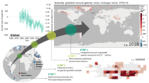
The dataset provides global annual glacier mass changes distributed on a global regular grid at 0.5° resolution (latitude, longitude) based on the Fluctuations of Glaciers (FoG) database of the World Glacier Monitoring Service (WGMS). Glaciers play a fundamental role in the Earth’s water cycles. They are one of the most important freshwater resources for societies and ecosystems and the recent increase in ice melt contributes directly to the rise of ocean levels.
Interval/period: Wed, 01/01/1975 - Sun, 05/10/2026
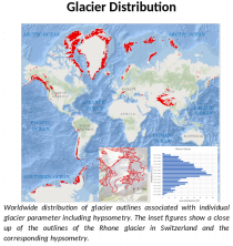
This dataset, commonly known as the Randolph Glacier Inventory (RGI), provides global glacier outlines compiled from maps, aerial photographs and satellite images. The data is provided as a "snapshot" (single time-slice) constructed from images that were mostly acquired in the period 2000-2010.
Interval/period: Sat, 01/01/2000 - Sun, 12/31/2000