This dataset provides estimates of water vapour derived from atmospheric delays in Global Navigation Satellite System
(GNSS) radio signals.
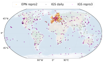
The initial data is collected from two in situ ground-based network of GNSS receivers – the International GNSS Service
(IGS) and EUREF Permanent Network (EPN). The IGS collects, archives, and freely distributes GNSS data from a
cooperatively operated global network of more than 500 ground-based GNSS stations since 1994. The EPN is a European

calendar_today Interval/period: Mon, 01/01/1996 - Sun, 05/10/2026

This dataset provides lake water levels for 311 selected lakes on four continents derived from satellite radar altimetry.

calendar_today Interval/period: Wed, 01/01/1992 - Sun, 05/10/2026

This dataset contains 4 Essential Climate Variables (ECV) for the 18 bias adjusted Global Climate Models (GCM) from CMIP5: daily precipitation rate, and daily mean, maximum and minimum temperatures.
The data are bias adjusted using the Distribution Based Scaling (DBS) method versus the global reference dataset HydroGFD2.0, both bias adjustment method and global reference dataset developed by the Swedish Meteorological and Hydrological Institute (SMHI).
The DBS method is a parametric quantile-mapping variant.

calendar_today 
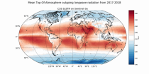
Interval/period: Thu, 10/12/2000 - Thu, 10/18/2018
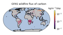
This dataset provides global information on the timing and location of Active Fires (AF) burning on Earth's surface during satellite overpasses, and also records their Fire Radiative Power (FRP) as a measure of strength. FRP relates to a fire's combustion rate, and the rate at which smoke containing greenhouse gases, reactive gases and particular matter is released into the atmosphere. The vast majority of detected hotspots are related to landscape fires, however other high temperature targets such as active volcanoes and gas flares are also present in the data.

calendar_today Interval/period: Wed, 01/01/2020 - Fri, 02/28/2025

This dataset provides agroclimatic indicators used to characterise plant-climate interactions for global agriculture. Agroclimatic indicators are useful in conveying climate variability and change in the terms that are meaningful to the agricultural sector. The objective of this dataset is to provide these indicators at a global scale in an easily accessible and usable format for further downstream analysis and the forcing of agricultural impact models.

calendar_today Interval/period: Mon, 01/01/1951 - Sun, 05/10/2026

This dataset provides monthly and zonally averaged tropospheric humidity profiles derived from globally distributed GPS radio occultation (RO) measurements from EUMETSAT's Metop polar-orbiting satellites. Humidity plays an important role in the Earth's climate system, due to the strong greenhouse effect of water vapour but also for its role in the global energy transport, vertically in the atmosphere and horizontally between different geographical regions.

calendar_today Interval/period: Fri, 12/01/2006 - Mon, 12/01/2025

Upper Tropospheric Humidity (UTH) is of key importance to the Earth’s greenhouse effect and understanding of climate change. It is considered an Essential Climate Variable (ECV) because it controls key atmospheric processes, including those involved in water vapour and cloud feedbacks, that can amplify the climate system’s response to increases in other greenhouse gases. The Upper Tropospheric Humidity is defined as the integrated amount of Water Vapour in the atmospheric layer between ~500 hPa and ~200 hPa.

calendar_today Interval/period: Tue, 07/05/1994 - Sun, 02/28/2021

The Sub-seasonal To Seasonal dataset (S2S) consists of global ensemble real-time forecasts and reforecasts from thirteen numerical weather prediction (NWP) and research centres.
S2S project behind the dataset started in 2013 as a joint initiative of the World Weather Research Programme (WWRP) and the World Climate Research Programme (WCRP).
The goal of S2S project was to improve sub-seasonal forecast skill through combining multiple forecasting systems, enable multi-model evaluations and enhance knowledge sharing between operational centres.

calendar_today Interval/period: Thu, 01/01/2015 - Wed, 05/06/2026

The Sub-seasonal To Seasonal dataset (S2S) consists of global ensemble real-time forecasts and reforecasts from thirteen numerical weather prediction (NWP) and research centres.
S2S project behind the dataset started in 2013 as a joint initiative of the World Weather Research Programme (WWRP) and the World Climate Research Programme (WCRP).
The goal of S2S project was to improve sub-seasonal forecast skill through combining multiple forecasting systems, enable multi-model evaluations and enhance knowledge sharing between operational centres.

calendar_today Interval/period: Tue, 03/01/2011 - Tue, 06/09/2026

CAMS produces global forecasts for atmospheric composition twice a day. The forecasts consist of more than 50 chemical species (e.g. ozone, nitrogen dioxide, carbon monoxide) and seven different types of aerosol (desert dust, sea salt, organic matter, black carbon, sulphate, nitrate and ammonium aerosol). In addition, several meteorological variables are available as well.

calendar_today Interval/period: Thu, 01/01/2015 - Thu, 05/07/2026

Emissions of atmospheric pollutants from biomass burning and vegetation fires are key drivers of the evolution of atmospheric composition, with a high degree of spatial and temporal variability, and an accurate representation of them in models is essential.

calendar_today Interval/period: Wed, 01/01/2003 - Wed, 12/03/2025

CAMS produces global forecasts for the two main long-lived greenhouse gases once a day. This dataset consists of 5-day high-resolution forecasts of carbon dioxide (CO2) and methane (CH4). Additionally, carbon monoxide (CO) and meteorological parameters relevant to the CAMS greenhouse gas forecast are included.

calendar_today Interval/period: Fri, 03/01/2024 - Thu, 05/07/2026

Cloud properties directly influence the state of the Earth´s upper-air atmosphere. Clouds have an effect on weather and climate through their contribution to the Earth’s water cycle and impact on the Earth’s energy budget. They impact atmospheric motions on a range of spatial and temporal scales and contribute to changes in the atmospheric composition.

calendar_today Interval/period: Mon, 01/01/1979 - Mon, 06/30/2025

This catalogue entry provides daily climate projections on pressure levels from a large number of experiments, models, members and time periods computed in the framework of fifth phase of the Coupled Model Intercomparison Project (CMIP5). The term "pressure levels" is used to express that the variables were computed at multiple vertical levels, which may differ in number and location among the different models.

calendar_today Interval/period: Sun, 01/01/1860 - Mon, 12/31/2300

This catalogue entry provides daily climate projections on single levels from a large number of experiments, models, members and time periods computed in the framework of the fifth phase of the Coupled Model Intercomparison Project (CMIP5). The term "single levels" is used to express that the variables are computed at one vertical level which can be surface (or a level close to the surface) or a dedicated pressure level in the atmosphere. Multiple vertical levels are excluded from this catalogue entry.

calendar_today Interval/period: Wed, 01/01/1800 - Fri, 12/31/2100

This catalogue entry provides monthly climate projections on pressure levels from a large number of experiments, models, members and time periods computed in the framework of the fifth phase of the Coupled Model Intercomparison Project (CMIP5). The term "pressure levels" is used to express that the variables were computed at multiple vertical levels, which may differ in number and location among the different models.

calendar_today Interval/period: Sun, 01/01/1860 - Mon, 12/31/2300

This catalogue entry provides monthly climate projections on single levels from a large number of experiments, models, members and time periods computed in the framework of fifth phase of the Coupled Model Intercomparison Project (CMIP5). The term "single levels" is used to express that the variables are computed at one vertical level which can be surface (or a level close to the surface) or a dedicated pressure level in the atmosphere. Multiple vertical levels are excluded from this catalogue entry.

calendar_today Interval/period: Sun, 01/01/1860 - Mon, 12/31/2300

This catalogue entry provides daily and monthly global climate projections data from a large number of experiments, models and time periods computed in the framework of the sixth phase of the Coupled Model Intercomparison Project (CMIP6).
CMIP6 data underpins the Intergovernmental Panel on Climate Change 6th Assessment Report. The use of these data is mostly aimed at:

addressing outstanding scientific questions that arose as part of the IPCC reporting process;
improving the understanding of the climate system;

calendar_today Interval/period: Sun, 01/01/1860 - Mon, 12/31/2300

This catalogue entry provides daily and monthly global climate model data from Decadal Climate Predictions Project (DCPP) experiments, part of the sixth phase of the Coupled Model Intercomparison Project (CMIP6). The decadal data in the Climate Data Store (CDS) are a quality-controlled subset of the full DCPP.

calendar_today Interval/period: Sun, 01/01/1860 - Mon, 12/31/2300

This dataset provides daily and monthly fields of global sea surface temperature (SST) and sea ice surface temperature (IST) from 1982 to the present, using observations from multiple infrared and passive microwave satellite sensors. SST is a key driver of global weather and climate, affecting ocean-atmosphere interactions and driving climate variability.

calendar_today Interval/period: Fri, 01/01/1982 - Tue, 12/31/2024

ERA5 is the fifth generation ECMWF atmospheric reanalysis of the global climate covering the period from January 1940 to present. It is produced by the Copernicus Climate Change Service (C3S) at ECMWF and provides hourly estimates of a large number of atmospheric, land and oceanic climate variables. The data cover the Earth on a 31km grid and resolve the atmosphere using 137 levels from the surface up to a height of 80km. ERA5 includes an ensemble component at half the resolution to provide information on synoptic uncertainty of its products.

calendar_today Interval/period: Sat, 01/01/1949 - Sun, 05/10/2026

The Earth’s Radiation Budget (ERB) represents the overall balance between incoming and outgoing radiant energy at the Earth’s top-of-the-atmosphere. This Essential Climate Variable is the primary forcing of the climate system and is therefore a fundamental quantity to be monitored to understand the Earth’s climate and its variability. The Earth’s Radiation Budget comprises of the quantification of the incoming radiation from the Sun and the outgoing reflected shortwave and emitted longwave radiation.

calendar_today Interval/period: Mon, 01/01/1979 - Sun, 02/01/2026

Atmospheric water vapor, quantified here as Total Column Water Vapor (TCWV), holds paramount importance in monitoring and understanding Earth's climate dynamics. Its role as an Essential Climate Variable is pivotal, serving as the foundation for cloud formation, cloud physics, and significantly impacting the Earth's heat budget through its proficient absorption of both long and short-wave radiation.
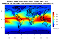
This catalogue entry presents two extensive, high-quality observational datasets of TCWV, specifically tailored for climate analysis and applications.

calendar_today Interval/period: Tue, 01/01/2002 - Sun, 12/31/2017

This dataset provides daily and monthly global estimates of sea surface temperature (SST) based on observations from multiple satellite sensors since July 1979 (for the daily product) and January 1980 respectivly (for the monthly product). SST is a key driver of global weather and climate patterns and plays an important role in the exchanges of energy, momentum, moisture and gases between the ocean and atmosphere. Accurate SST data are therefore essential for understanding and assessing variability and long-term changes in the Earth’s climate.

calendar_today Interval/period: Fri, 07/13/1979 - Tue, 04/21/2026

This catalogue entry provides the gridded climate data (monthly/annual timeseries) used for the Copernicus Climate Change Service Atlas (C3S Atlas). The gridded datasets consist of in-situ and satellite observation-based datasets, reanalyses (CERRA, ERA5, ERA5-Land, and ORAS5) and global (CMIP5 and CMIP6) and regional (CORDEX) climate projections for the variables and indices included in the C3S Atlas.

calendar_today Interval/period: Sun, 01/01/1860 - Mon, 12/31/2300