Datasets
Displaying 1 - 3 of 3
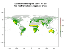
This data set provides complete historical reconstruction of meteorological conditions favourable to the start, spread and sustainability of fires. The fire danger metrics provided are part of a vast dataset produced by the Copernicus Emergency Management Service for the
Interval/period: Wed, 01/03/1940 - Tue, 05/05/2026
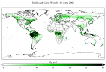
This dataset provides a record of fuel characteristics at high spatiotemporal resolution: ~9km, daily.
The two main variable groups are fuel load and fuel moisture, both of which are further divided by live/dead and wood/foliage fractions.
The dataset combines state-of-the-art model data (ERA5-Land) with observations from multiple satellites and in-situ variables into a globally complete and consistent dataset.
Interval/period: Wed, 01/01/2003 - Fri, 12/31/2021
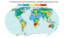
This dataset offers modeled daily fire danger time series, driven by seasonal weather forecasts. It provides long-range predictions of meteorological conditions conducive to the initiation, spread, and persistence of fires. The fire danger metrics included in this dataset are part of an extensive dataset produced by the Copernicus Emergency Management Service (CEMS) for the European Forest Fire Information System (EFFIS) and the Global Wildfire Information System (GWIS).
Interval/period: Sun, 02/01/1981 - Wed, 04/01/2026