Datasets
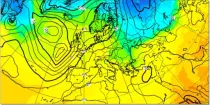
GraphCast (Google DeepMind): a deep learning-based system developed by Google DeepMind.It is initialised with ECMWF analysis. GraphCast operates at 0.25° resolution.
Interval/period: N/A
GraphCast (Google DeepMind): a deep learning-based system developed by Google DeepMind.It is initialised with ECMWF analysis. GraphCast operates at 0.25° resolution.
Interval/period: N/A
GraphCast (Google DeepMind): a deep learning-based system developed by Google DeepMind.It is initialised with ECMWF analysis. GraphCast operates at 0.25° resolution.
Interval/period: N/A
GraphCast (Google DeepMind): a deep learning-based system developed by Google DeepMind.It is initialised with ECMWF analysis. GraphCast operates at 0.25° resolution.
Interval/period: N/A
GraphCast (Google DeepMind): a deep learning-based system developed by Google DeepMind.It is initialised with ECMWF analysis. GraphCast operates at 0.25° resolution.
Interval/period: N/A
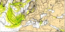
Pangu-Weather: a deep learning-based system developed by Huawei. It is initialised with ECMWF analysis. Pangu-Weather operates at 0.25° resolution.
Interval/period: N/A
Pangu-Weather: a deep learning-based system developed by Huawei. It is initialised with ECMWF analysis. Pangu-Weather operates at 0.25° resolution.
Interval/period: N/A
Pangu-Weather: a deep learning-based system developed by Huawei. It is initialised with ECMWF analysis. Pangu-Weather operates at 0.25° resolution.
Interval/period: N/A

Pangu-Weather: a deep learning-based system developed by Huawei. It is initialised with ECMWF analysis. Pangu-Weather operates at 0.25° resolution.
Interval/period: N/A
Pangu-Weather: a deep learning-based system developed by Huawei. It is initialised with ECMWF analysis. Pangu-Weather operates at 0.25° resolution.
Interval/period: N/A
Pangu-Weather: a deep learning-based system developed by Huawei. It is initialised with ECMWF analysis. Pangu-Weather operates at 0.25° resolution.
Interval/period: N/A

Coupled ensemble forecasts (60 days, 8+1 members), 1 Jan 1981-2016, IFS-CY43R3 TCo319L91, no initial perturbations, SPPT applied only in (50E-120E, 20N-20S). Twice-daily global pressure-level gridded F80 atmospheric fields.
Examples
Interval/period: N/A
Coupled ensemble forecasts (60 days, 50+1 members), 1 Jan 1987,1990,1995,2010,2013, IFS-CY43R3 TCo319L91, no initial perturbations, SPPT applied only in (50E-120E, 20N-20S). Twice-daily global pressure-level gridded F80 atmospheric fields.
Examples
Interval/period: N/A
Coupled ensemble forecasts (60 days, 8+1 members), 1 Nov 1981-2016, IFS-CY43R3 TCo319L91, no initial perturbations, SPPT applied only in (50E-120E, 20N-20S). Twice-daily global pressure-level gridded F80 atmospheric fields.
Examples
Interval/period: N/A
Coupled ensemble forecasts (60 days, 50+1 members), 1 Nov 2002, IFS-CY43R3 TCo319L91, no initial perturbations, SPPT applied only in (50E-120E, 20N-20S). Twice-daily global pressure-level gridded F80 atmospheric fields.
Examples
Interval/period: N/A

15-member coupled IFS (cycle 43R1) extended-range reforecast experiment covering the period 1989-2015. The atmosphere is configured with 91 vertical levels and uses the Tco399 cubic octahedral reduced Gaussian grid. The IFS is coupled hourly to the 75 level version of the NEMO v3.4 ocean model and the LIM2 sea-ice model, both of which use the ORCA025 tripolar grid. Coupling follows the implementation used in ECMWF operational forecasts.
Interval/period: N/A
15-member coupled IFS (cycle 43R1) extended-range reforecast experiment covering the period 1989-2015 with bias-corrected sea-surface temperatures (SSTs) in the North Atlantic region. This experiment can be compared with gkzp, which is the relevant control without bias-correction. The atmosphere is configured with 91 vertical levels and uses the Tco399 cubic octahedral reduced Gaussian grid.
Interval/period: N/A

Interval/period: Sun, 01/01/1950 - Tue, 12/31/2019
Interval/period: Mon, 01/01/2001 - Fri, 04/01/2022

Interval/period: N/A
Interval/period: Wed, 01/03/1940 - Tue, 05/05/2026
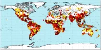
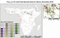
Fire radiative power and active fire pixels from 2020 to present derived from satellite observations

Interval/period: Wed, 01/01/2020 - Fri, 02/28/2025
Research forecast experiment produced with ECMWF IFS cycle 47R1, at TCo399 (25km), for the EUREC4A field campaign (15.01.2020-14.02.2020). Initialized from the hfa8 analysis, in which no dropsondes are assimilated, with fields saved on model levels (bit identical to hfa8 forecasts)
Examples
Interval/period: N/A
Research forecast experiment produced with ECMWF IFS cycle 47R1, at TCo399 (25km), for the EUREC4A field campaign (15.01.2020-14.02.2020). Initialized from the hfff analysis, in which no dropsondes and no radiosondes are assimilated, with fields saved on model levels (bit identical to hfff forecasts)
Examples
Interval/period: N/A