Datasets
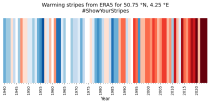
Data is available from 1940 onwards.
ERA5 replaces the ERA-Interim reanalysis.
Interval/period: Mon, 01/01/1940 - Sat, 05/02/2026
Data is available from 1940 onwards. ERA5 replaces the ERA-Interim reanalysis.
Interval/period: Mon, 01/01/1940 - Fri, 12/06/2024

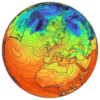
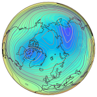
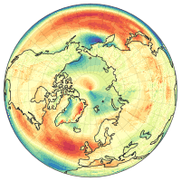
Fifth Generation of the European Centre for Medium-Range Weather Forecasts (ECMWF) Reanalysis (ERA5).
Produced by replaying only the land component of the ECMWF ERA5 climate reanalysis, it benefits from the same physical data-assimilation framework but runs offline at
higher spatial detail (9 km grid) to deliver richer land-surface information.
Interval/period: Sun, 01/01/1950 - Thu, 12/31/2026
Data is available from 1940 onwards.
ERA5 replaces the ERA-Interim reanalysis.
Interval/period: Mon, 01/01/1940 - Wed, 04/01/2026
Data is available from 1940 onwards.
ERA5 replaces the ERA-Interim reanalysis.
Interval/period: Mon, 01/01/1940 - Wed, 04/01/2026
Data is available from 1940 onwards.
ERA5 replaces the ERA-Interim reanalysis.
Interval/period: Mon, 01/01/1940 - Sat, 05/02/2026
Data is available from 1940 onwards.
ERA5 replaces the ERA-Interim reanalysis.
Interval/period: Mon, 01/01/1940 - Sat, 05/02/2026

Interval/period: Sun, 01/01/1950 - Sat, 05/02/2026

Interval/period: Sun, 01/01/1950 - Wed, 04/01/2026

Interval/period: Sun, 01/01/1950 - Sat, 05/02/2026

This experiment is a prototype. It has several important limitations. It is not an ERA6 production. It has known missing components. It should not be used for any application or publication. It should be used to provide feedback to ECMWF.
Examples
Interval/period: N/A
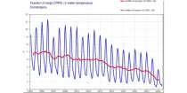
This diagram gives a measure of the effectiveness of the model. ...
Interval/period: N/A

This diagram gives a measure of the effectiveness of the model. ...
Interval/period: N/A
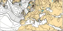
Where precipitation is forecast, a type of precipitation can be assigned according to the temperature structure of the model atmosphere that includes the layers through which the model precipitation falls...
Interval/period: N/A
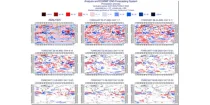
Forecasts using IFS EPS CY47R3 replicating operations (51 members, TCo639, ORCA025Z75). The ocean state has had a hydrostatically balanced estimate of anthropogenic influence (warming) since 1850-1900 added, such that the total anthropogenic influence is twice estimated at the present day (an equal but opposite perturbation to expid b2nn). The CO2 concentration was set to 625 ppm.
Interval/period: N/A
Forecasts using IFS EPS CY47R2 replicating operations (51 members, TCo639, ORCA025Z75). The ocean state has had a hydrostatically balanced estimate of anthropogenic influence (warming) since 1850-1900 added, such that the total anthropogenic influence is twice estimated at the present day (an equal but opposite perturbation to expid b2mg). The CO2 concentration was set to 615 ppm. If you are interested in using these data, please let us know by contacting nicholas.leach@physics.ox.ac.uk .
Interval/period: N/A
Forecasts using IFS EPS CY47R2 replicating operations (51 members, TCo639, ORCA025Z75). The ocean state has had a hydrostatically balanced estimate of anthropogenic influence (warming) within the CMCC-CM2-HR4 climate model since 1850-1900 added, such that the total anthropogenic influence is twice estimated at the present day (an equal but opposite perturbation to expid b2mk). The CO2 concentration was set to 615 ppm.
Interval/period: N/A
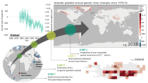
Interval/period: Wed, 01/01/1975 - Sat, 05/09/2026
Interval/period: Sat, 01/01/2000 - Sun, 12/31/2000
**Note:** In **June 2023** ECMWF implemented a **major upgrade ...**
Interval/period: N/A
Interval/period: Sun, 01/01/1950 - Thu, 12/31/2099
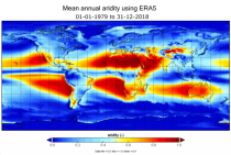
Interval/period: Mon, 01/01/1979 - Mon, 12/31/2018
Interval/period: Sun, 01/01/1978 - Wed, 10/17/2018
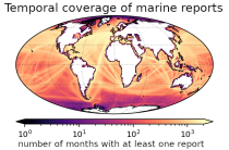
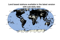
and naval ships, drifting buoys and other platforms and vessels over
the global ocean. Data have been collated and harmonised and quality control checks have been performed, but no attempt
has been made to assess or correct for potential biases.
Data are provided for a range of commonly observed variables.
Interval/period: Tue, 01/01/1850 - Sat, 05/09/2026
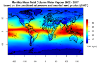
This catalogue entry presents two extensive, high-quality observational datasets of TCWV, specifically tailored for climate analysis and applications.
Interval/period: Tue, 01/01/2002 - Sun, 12/31/2017