The Global Climate Observing System (GCOS) Reference Upper-Air Network (GRUAN) is an international reference observing network, established in 2006, of sites measuring essential climate variables above Earth's surface, designed to fill an important gap in the current global observing system. GRUAN measurements are providing high-quality climate data records from the surface, through the troposphere, and into the stratosphere.

calendar_today Interval/period: Sun, 01/01/1978 - Wed, 10/17/2018

This dataset provides access to two types of ozone observations: total column ozone estimates and vertical profiles of ozone concentration.
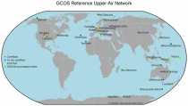
The total ozone estimates are based on solar UV radiation measurements made by ground-based spectrophotometers (Dobson or Brewer type spectrophotometers).
The vertical profiles of ozone concentration are estimated primarily using ozonesonde observations.
Data are available for 159 Dobson stations, 109 Brewer stations and 135 ozonesondes stations.

calendar_today Interval/period: Tue, 01/01/1924 - Sat, 05/09/2026

This dataset provides estimates of water vapour derived from atmospheric delays in Global Navigation Satellite System
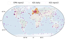
(GNSS) radio signals.
The initial data is collected from two in situ ground-based network of GNSS receivers – the International GNSS Service
(IGS) and EUREF Permanent Network (EPN). The IGS collects, archives, and freely distributes GNSS data from a
cooperatively operated global network of more than 500 ground-based GNSS stations since 1994. The EPN is a European

calendar_today Interval/period: Mon, 01/01/1996 - Sat, 05/09/2026

This dataset contains monthly daytime and nighttime clear-sky land surface temperatures (LSTs) and their uncertainty estimates from multiple Infra-Red (IR) instruments on polar orbiting satellites. Daytime and nighttime temperatures correspond to 10:00 and 22:00 local solar time (local solar time is defined as the time in a 24 hour day with 12 noon occurring when the sun is at its highest point at that longitude).

calendar_today Interval/period: Thu, 06/01/1995 - Tue, 12/31/2024

This catalogue entry provides access to vertical profiles of standard meteorological variables. It includes two archives.
The first is version 2 of the Integrated Global Radiosounding Archive (IGRA) from 1978 which incorporates global
radiosounding profiles of temperature, humidity and wind from a large number of data sources,
which is 30% larger than the previous version 1. IGRA v2 is the result of quality assurance procedures applied to the

calendar_today Interval/period: Sun, 01/01/1978 - Sat, 05/09/2026

The dataset contains model projections of changes in marine physics and biogeochemistry and the lower trophic levels of the marine food web across the Northwest European Shelf and Mediterranean Sea out to the year 2100.

calendar_today Interval/period: Mon, 01/01/1979 - Mon, 12/31/2018

This dataset provides monthly means of mass-consistent, vertically integrated, atmospheric energy and moisture budget quantities derived from 1-hourly ERA5 reanalysis data.
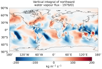
The vertically integrated budget diagnostics include the tendencies and lateral fluxes of total energy, water vapour, and latent heat (with the latent heat of vaporization varying with temperature). In addition, the divergences of the lateral fluxes are provided.

calendar_today Interval/period: Mon, 01/01/1979 - Sat, 05/09/2026

This dataset provides gridded sea ice thickness data for the Arctic, derived from satellite observations. Sea ice plays a vital role in the climate system, influencing air-sea interactions, the Earth’s energy balance, and marine ecosystems. It is recognised by the Global Climate Observing System (GCOS) as an Essential Climate Variable (ECV). Sea ice thickness is a key characteristic used alongside other parameters such as concentration, edge, and type, all available in the Climate Data Store (CDS).

calendar_today Interval/period: Tue, 10/01/2002 - Sat, 04/12/2025

This dataset provides gridded daily and monthly mean global estimates of sea level anomaly based on satellite altimetry measurements. The rise in global mean sea level in recent decades has been one of the most important and well-known consequences of climate warming, putting a large fraction of the world population and economic infrastructure at greater risk of flooding. However, changes in the global average sea level mask regional variations that can be one order of magnitude larger.

calendar_today Interval/period: Fri, 01/01/1993 - Sun, 12/31/2023

This dataset contains 4 Essential Climate Variables (ECV) for the 18 bias adjusted Global Climate Models (GCM) from CMIP5: daily precipitation rate, and daily mean, maximum and minimum temperatures.
The data are bias adjusted using the Distribution Based Scaling (DBS) method versus the global reference dataset HydroGFD2.0, both bias adjustment method and global reference dataset developed by the Swedish Meteorological and Hydrological Institute (SMHI).
The DBS method is a parametric quantile-mapping variant.

calendar_today Interval/period: Thu, 10/12/2000 - Thu, 10/18/2018

The dataset presents climate impact indicators related to extreme precipitation in Europe under current climate conditions. The suite of indicators include recent historic records, recurrence intervals, and other relevant statistical measures to evaluate the magnitude and frequency of extreme precipitation events. These are provided as gridded products, with one product covering the whole of Europe, and the other higher resolution product focused on 20 European cities that were identified as vulnerable to urban pluvial flooding based on stakeholder surveys.

calendar_today Interval/period: Sun, 01/01/1950 - Tue, 12/31/2019

This dataset provides daily surface meteorological data for the period from 1979 to present as input for agriculture and agro-ecological studies. This dataset is based on the hourly ECMWF ERA5 data at surface level and is referred to as AgERA5. Acquisition and pre-processing of the original ERA5 data is a complex and specialized job. By providing the AgERA5 dataset, users are freed from this work and can directly start with meaningful input for their analyses and modelling.

calendar_today Interval/period: Mon, 01/01/1979 - Thu, 04/30/2026

This dataset provides global estimates of daily accumulated and monthly means of precipitation. The precipitation estimates are based on a merge of passive microwave observations from two different radiometer classes operating on multiple Low Earth Orbit (LEO) satellites.

calendar_today Interval/period: Sat, 01/01/2000 - Sun, 12/31/2017

The present UERRA dataset contains analyses of atmospheric variables on height levels, from 1961 to 2019.

calendar_today Interval/period: Thu, 10/18/2018 - Wed, 07/31/2019

The present UERRA dataset contains analyses of atmospheric variables on pressure levels, from 1961 to 2019.
It has been generated using the UERRA-HARMONIE system by combining model data with observations into a complete and consistent dataset using the laws of physics.

calendar_today Interval/period: Thu, 10/18/2018 - Wed, 07/31/2019

This UERRA dataset contains analyses of surface and near-surface essential climate variables from
UERRA-HARMONIE and MESCAN-SURFEX systems. Forecasts up to 30 hours initialised
from the analyses at 00 and 12 UTC are available only through the CDS-API (see Documentation).
UERRA-HARMONIE is a 3-dimensional variational data assimilation system,
while MESCAN-SURFEX is a complementary surface analysis system.
Using the Optimal Interpolation method, MESCAN provides the best estimate of daily accumulated precipitation

calendar_today Interval/period: Thu, 10/18/2018 - Wed, 07/31/2019

The UERRA dataset provides estimations of the climate in Europe based on model data
combined with observations using the UERRA-HARMONIE system and MESCAN-SURFEX system.
UERRA-HARMONIE is a 3-dimensional data assimilation system, whereas
MESCAN-SURFEX is a complementary surface analysis system. In general, the
assimilation systems are able to estimate biases between observations and to
sift good-quality data from poor data. The laws of physics allow for estimates

calendar_today Interval/period: Thu, 10/18/2018 - Wed, 07/31/2019

Upper Tropospheric Humidity (UTH) is of key importance to the Earth’s greenhouse effect and understanding of climate change. It is considered an Essential Climate Variable (ECV) because it controls key atmospheric processes, including those involved in water vapour and cloud feedbacks, that can amplify the climate system’s response to increases in other greenhouse gases. The Upper Tropospheric Humidity is defined as the integrated amount of Water Vapour in the atmospheric layer between ~500 hPa and ~200 hPa.

calendar_today Interval/period: Tue, 07/05/1994 - Sun, 02/28/2021

This dataset provides climate indicators of windstorms associated with extratropical cyclones, derived from the fifth generation of the European Centre for Medium-Range Weather Forecasts (ECMWF) atmospheric reanalyses (ERA5) over a pan-European domain. Developed as part of Copernicus Climate Change Service's (C3S) Enhanced Windstorm Service (EWS), and responding to requirements from users in the insurance sector, this dataset extends the previous C3S Windstorm Service (winter months only) to include the entire year.

calendar_today Interval/period: Thu, 02/01/1940 - Fri, 01/23/2026

This dataset provides climatological indicators on European winter windstorms and their economic impact derived from ERA5 reanalysis. Also provided are risk indicators from a synthetically derived set of physically realistic windstorm events based on modelled climatic conditions. The primary users include the insurance sector, reinsurers and insurance industry service providers in response to their requirements for a catalogue of historic windstorm events within Europe.

calendar_today Interval/period: Sat, 03/01/1986 - Wed, 11/30/2011

This dataset provides gridded modelled hydrological time series forced with medium-range meteorological forecasts. The data is a consistent representation of the most important hydrological variables across the European Flood Awareness System (EFAS) domain. The temporal resolution is sub-daily high-resolution and ensemble forecasts of:

River discharge
Soil moisture for three soil layers
Snow water equivalent

calendar_today Interval/period: N/A

This dataset, also known as the Long-term Alpine Precipitation Reconstruction (LAPrec), provides gridded fields of monthly precipitation for the Alpine region (eight countries). The dataset is derived from station observations and is provided in two issues:

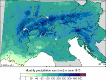
LAPrec1871 starts in 1871 and is based on data from 85 input series;
LAPrec1901 starts in 1901 and is based on data from 165 input series.

calendar_today Interval/period: Sun, 01/01/1871 - Sat, 05/09/2026

The Pan-European Climate Database (PECD) provides information on climate and renewable energy variables for both historical and future time periods. For historical data, the ERA5 global reanalysis serves as the underlying climate data, while future projections are based on selected CMIP6 global climate models. The raw climate model data are further processed through downscaling to achieve higher spatial and temporal resolution and by applying bias adjustment.

calendar_today Interval/period: Sun, 01/01/1950 - Wed, 12/01/2100

This dataset provides a series of climate indices derived from reanalysis and model simulations data hosted on the Copernicus Climate Data Store (CDS). These indicators describe how climate variability and change of essential climate variables can impact sectors such as health, agriculture, forestry, energy, tourism, or water and coastal management.

calendar_today Interval/period: Mon, 01/01/1940 - Fri, 12/31/2100

This dataset contains climatic suitability indicators for the Aedes albopictus (tiger mosquito) for Europe produced within the C3S European Health service. The provided indicators are the climatic suitability for the presence of Aedes albopictus and the season length of presence of Aedes albopictus. This mosquito transmits vector-borne diseases, such as dengue and chikungunya.

calendar_today Interval/period: N/A