Datasets

Single prediction that uses
observations prior information about the Earth-system ECMWF's highest-resolution modelHRES Direct model output Products offers "High Frequency products"
4 forecast runs per day (00/06/12/18) (see dissemination schedule for details) Hourly steps to step 90 for all four runs.Not all post-processed Products are available at 06/18 runs or in hourly steps.
Interval/period: N/A
The sub-seasonal products comprise ensembles of individual forecasts up to 46 days and post-processed products of average conditions (e.g. weekly averages) and the associated uncertainty.
The purchase of the "Basic Set" +72, +96, +120, +144, +168 hrs is a mandatory prerequisite for the purchase of time steps in the range 12 to 66 hours.
The following sub-sets are available from the sub-seasonal forecast (46 days):
Interval/period: N/A
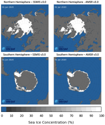
This dataset provides daily gridded data of sea ice concentration for both hemispheres derived from satellite passive microwave brightness temperatures. Sea ice is an important component of our climate system and a sensitive indicator of climate change. Its presence or its retreat has a strong impact on air-sea interactions, the Earth’s energy budget as well as marine ecosystems. It is listed as an Essential Climate Variable by the Global Climate Observing System.
Interval/period: N/A
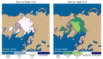
This dataset provides daily gridded data of sea ice edge and sea ice type derived from brightness temperatures measured by satellite passive microwave radiometers. Sea ice is an important component of our climate system and a sensitive indicator of climate change. Its presence or its retreat has a strong impact on air-sea interactions, the Earth’s energy budget as well as marine ecosystems. It is recognized by the Global Climate Observing System as an Essential Climate Variable. Sea ice edge and type are some of the parameters used to characterise sea ice.
Interval/period: N/A
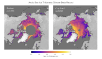
This dataset provides monthly gridded data of sea ice thickness for the Arctic region based on satellite radar altimetry observations. Sea ice is an important component of our climate system and a sensitive indicator of climate change. Its presence or its retreat has a strong impact on air-sea interactions, the Earth’s energy budget as well as marine ecosystems. It is recognized by the Global Climate Observing System as an Essential Climate Variable.
Interval/period: N/A
These seasonal data comprises ensembles of individual forecasts coupled to an ocean model and post-processed products of average conditions (e.g. monthly averages) with the associated uncertainty. Products are available for forecast month 8-13, each quarter (February, May, August, November).
The following sub-sets are available:
Interval/period: N/A
This licence provides access to ECMWF interactive ecCharts tool to visualise analysis and forecast products Please note that access to the ecCharts is for End User use only (internal).
ECMWF ecCharts web service is available and we are pleased to be able to offer the service for evaluation to customers of ECMWF's web products.
Interval/period: N/A
Ensemble forecast runs produced by the ECMWF Artificial Intelligence Forecasting System (AIFS) Ensemble model.
4 forecast runs per day (00/06/12/18) 6 hourly steps to 360 (15 days)More information can be found on the implementation page.
X-i: AIFS ENS forecastProduct description
Interval/period: N/A
On 12 May 2026, a new forecast stream will be produced by ECMWF's operational Artificial Intelligence Forecasting System ensemble model (AIFS ENS).
The new forecast stream is for wave forecast runs, marking ECMWF's first operational data-driven wave forecasts.
Interval/period: N/A

The DestinE Digital Twin for Weather-Induced Extremes (Extremes DT) supports responding and adapting to extreme events in a changing world by providing a capability to produce tailored simulations and address what-if scenarios related to extreme events in a past, present and future climate, complementing existing capabilities at national and European level.
Interval/period: N/A

This dataset provides gridded modelled hydrological time series forced with medium-range meteorological forecasts. The data is a consistent representation of the most important hydrological variables across the European Flood Awareness System (EFAS) domain. The temporal resolution is sub-daily high-resolution and ensemble forecasts of:
River discharge
Soil moisture for three soil layers
Snow water equivalent
Interval/period: N/A
Single forecast runs produced by the ECMWF Artificial Intelligence Forecasting System (AIFS) deterministic model.
Interval/period: N/A
On 12 May 2026, a new forecast stream will be produced by ECMWF's operational Artificial Intelligence Forecasting System deterministic model (AIFS Single).
The new forecast stream is for wave forecast runs, marking ECMWF's first operational data-driven wave forecasts.
Interval/period: N/A
Ensemble (ENS) of forecasts providing an estimate of the reliability of a single forecast.
ENS offers "High Frequency products" until step 144:
4 daily runs: 00, 06, 12 and 18 UTC hourly until step 90 3-hourly from 93 to 144Most Post-processed Products are not available at 06/18 runs or in hourly steps. An exception are Tropical Cycle tracks (set III-viii) which is available for all daily runs: 00, 06, 12 and 18 UTC.
Interval/period: N/A

This dataset provides daily air quality analyses and forecasts for Europe.
Interval/period: N/A

This dataset provides annual air quality reanalyses for Europe based on both unvalidated (interim) and validated observations.
Interval/period: N/A
CAMS Global atmospheric composition forecast production system is used to produce the daily forecasts of pollutants, aerosols and greenhouse gases across the globe. Satellite observations of atmospheric composition are merged with a detailed computer simulation of the atmosphere using a method called data assimilation. The resulting analyses, i.e.
Interval/period: N/A
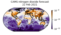
CAMS produces global forecasts for atmospheric composition twice a day. The forecasts consist of more than 50 chemical species (e.g. ozone, nitrogen dioxide, carbon monoxide) and seven different types of aerosol (desert dust, sea salt, organic matter, black carbon, sulphate, nitrate and ammonium aerosol). In addition, several meteorological variables are available as well.
Interval/period: N/A

Emissions of atmospheric pollutants from biomass burning and vegetation fires are key drivers of the evolution of atmospheric composition, with a high degree of spatial and temporal variability, and an accurate representation of them in models is essential.
Interval/period: N/A
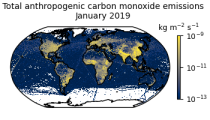
This data set contains gridded distributions of global anthropogenic and natural emissions.
Interval/period: N/A
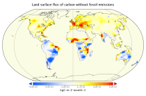
This dataset is part of the ECMWF Atmospheric Composition Reanalysis focusing on long-lived greenhouse gases: carbon dioxide (CO2) and methane (CH4). The emissions and natural fluxes at the surface are crucial for the evolution of the long-lived greenhouse gases in the atmosphere. In this dataset the CO2 fluxes from terrestrial vegetation are modelled in order to simulate the variability across a wide range of scales from diurnal to inter-annual.
Interval/period: N/A
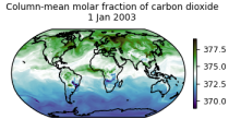
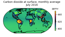
This data set contains net fluxes at the surface, atmospheric mixing ratios at model levels, and column-mean atmospheric mixing ratios for carbon dioxide (CO2), methane (CH4) and nitrous oxide (N20).
Interval/period: N/A

This dataset provides aerosol optical depths and aerosol-radiation radiative effects for four different aerosol origins: anthropogenic, mineral dust, marine, and land-based fine-mode natural aerosol. The latter mostly consists of biogenic aerosols.
Interval/period: N/A

This dataset provides geographical distributions of the radiative forcing (RF) by key atmospheric constituents. The radiative forcing estimates are based on the CAMS reanalysis and additional model simulations and are provided separately for...
- carbon dioxide
- methane
- tropospheric ozone
- stratospheric ozone
- interactions between anthropogenic aerosols and radiation
Interval/period: N/A