Datasets
Displaying 1 - 4 of 4
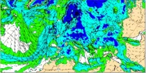
Uncoloured areas (relative humidity < 65%) are likely to be free of cloud. Coloured areas (relative humidity > 65%) show where moisture is likely to be available for cloud development...
Interval/period: N/A

ERA-Interim/Land is a global reanalysis of land-surface parameters from 1979-2010 at 80 km spatial resolution. It was produced with a recent version of the HTESSEL land-surface model using atmospheric forcing from ERA-Interim, with precipitation adjustments based on GPCP v2.1.
Interval/period: N/A
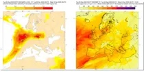
These charts aim to provide pointers to areas where anomalous values of water vapour flux are likely to occur based on the ECMWF en ...
Interval/period: N/A
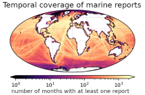
This set of holdings provides access to surface marine meteorological weather reports and observations made by merchant
and naval ships, drifting buoys and other platforms and vessels over
the global ocean. Data have been collated and harmonised and quality control checks have been performed, but no attempt
has been made to assess or correct for potential biases.
Data are provided for a range of commonly observed variables.
Interval/period: Tue, 01/01/1850 - Sat, 05/09/2026