Datasets
Displaying 1 - 2 of 2

ERA-Interim/Land is a global reanalysis of land-surface parameters from 1979-2010 at 80 km spatial resolution. It was produced with a recent version of the HTESSEL land-surface model using atmospheric forcing from ERA-Interim, with precipitation adjustments based on GPCP v2.1.
Interval/period: N/A
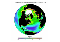
This dataset provides global daily estimates of ocean surface chlorophyll-a concentration and remote sensing reflectance derived from multiple satellite sensors. These two products are part of the broader discipline of ocean colour remote sensing, which analyses ocean surface radiances measured from space to derive information about the optical properties and constituents of the upper ocean.
Interval/period: Thu, 09/04/1997 - Tue, 12/31/2024