Datasets

Interval/period: Wed, 01/01/1992 - Sat, 01/01/2022

Interval/period: Thu, 06/01/1995 - Tue, 12/31/2024

Interval/period: Tue, 09/01/1981 - Sun, 12/01/2024
Interval/period: Mon, 01/01/2001 - Fri, 04/01/2022

Interval/period: N/A
Interval/period: Wed, 01/03/1940 - Tue, 05/05/2026
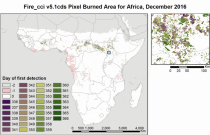
Fire radiative power and active fire pixels from 2020 to present derived from satellite observations

Interval/period: Wed, 01/01/2020 - Fri, 02/28/2025

Interval/period: Mon, 01/01/1951 - Sat, 05/09/2026
Interval/period: Mon, 01/01/1979 - Thu, 04/30/2026
Interval/period: Thu, 01/01/2015 - Thu, 05/07/2026

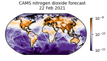
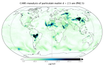
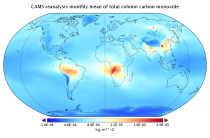
CAMS produces global forecasts for atmospheric composition twice a day. The forecasts consist of more than 50 chemical species (e.g. ozone, nitrogen dioxide, carbon monoxide) and seven different types of aerosol (desert dust, sea salt, organic matter, black carbon, sulphate, nitrate and ammonium aerosol). In addition, several meteorological variables are available as well.
Interval/period: N/A
Interval/period: Wed, 01/01/2003 - Thu, 12/31/2020

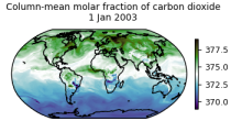
This dataset is part of the ECMWF Atmospheric Composition Reanalysis focusing on long-lived greenhouse gases: carbon dioxide (CO2) and methane (CH4). The emissions and natural fluxes at the surface are crucial for the evolution of the long-lived greenhouse gases in the atmosphere. In this dataset the CO2 fluxes from terrestrial vegetation are modelled in order to simulate the variability across a wide range of scales from diurnal to inter-annual.
Interval/period: N/A

Interval/period: Wed, 01/01/2003 - Thu, 12/31/2020
This dataset is part of the ECMWF Atmospheric Composition Reanalysis focusing on long-lived greenhouse gases: carbon dioxide (CO2) and methane (CH4). The emissions and natural fluxes at the surface are crucial for the evolution of the long-lived greenhouse gases in the atmosphere. In this dataset the CO2 fluxes from terrestrial vegetation are modelled in order to simulate the variability across a wide range of scales from diurnal to inter-annual.
Interval/period: N/A
Interval/period: Wed, 01/01/2003 - Thu, 10/31/2024

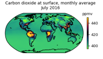
EAC4 (ECMWF Atmospheric Composition Reanalysis 4) is the fourth generation ECMWF global reanalysis of atmospheric composition. Reanalysis combines model data with observations from across the world into a globally complete and consistent dataset using a model of the atmosphere based on the laws of physics and chemistry.
Interval/period: N/A
Interval/period: Wed, 01/01/2003 - Sun, 12/31/2023

EAC4 (ECMWF Atmospheric Composition Reanalysis 4) is the fourth generation ECMWF global reanalysis of atmospheric composition. Reanalysis combines model data with observations from across the world into a globally complete and consistent dataset using a model of the atmosphere based on the laws of physics and chemistry.
Interval/period: N/A
Interval/period: Sat, 09/01/1984 - Sat, 01/31/2026
Interval/period: Sat, 09/01/1984 - Sat, 01/31/2026
Interval/period: Sat, 09/01/1984 - Sat, 01/31/2026

Interval/period: N/A

Interval/period: Mon, 01/01/1940 - Fri, 12/31/2100

Interval/period: N/A