Datasets

This product shows ENS meteograms from next model version of IFS cycle 50R1 that is planned to be ...
Interval/period: N/A

**This product shows ENS meteograms from next model version of IFS cycle 50R1 that is planned ...**
Interval/period: N/A

**Next IFS version (cycle 50r1)**. This product shows the probability of visibility (%) in 2 ...
Interval/period: N/A

(Next IFS version - CY50R1) Probability of precipitation type (%) in precipitation rate categories ...
Interval/period: N/A

(New IFS cycle 50R1) The Vertical Profiles display the vertical structure of the forecast model atmosphere in a familiar user friendly way. The vertical structure of temperatures (red) dewpoints (green) and dewpoint depressions (blue) from each ENS member ...
Interval/period: N/A

Interval/period: Thu, 06/01/1995 - Sat, 05/09/2026

Interval/period: Wed, 01/01/1992 - Sat, 05/09/2026

Interval/period: Wed, 01/01/1992 - Sat, 01/01/2022

Interval/period: Thu, 06/01/1995 - Tue, 12/31/2024

Interval/period: Tue, 09/01/1981 - Sun, 12/01/2024

Interval/period: Mon, 01/01/1979 - Wed, 04/01/2026

Interval/period: Sun, 01/01/1950 - Tue, 12/31/2019
Interval/period: Mon, 01/01/2001 - Fri, 04/01/2022

Interval/period: N/A
Interval/period: Wed, 01/03/1940 - Tue, 05/05/2026
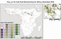
Fire radiative power and active fire pixels from 2020 to present derived from satellite observations

Interval/period: Wed, 01/01/2020 - Fri, 02/28/2025

Interval/period: Mon, 01/01/1951 - Sat, 05/09/2026
Interval/period: Mon, 01/01/1979 - Thu, 04/30/2026

Interval/period: Wed, 01/01/1986 - Sun, 12/31/2023

Interval/period: Wed, 01/01/1986 - Sun, 12/31/2023

Interval/period: Mon, 01/01/1979 - Mon, 09/30/2024

Interval/period: Sat, 01/01/2000 - Sun, 12/31/2017

combined with observations using the UERRA-HARMONIE system and MESCAN-SURFEX system.
UERRA-HARMONIE is a 3-dimensional data assimilation system, whereas
MESCAN-SURFEX is a complementary surface analysis system. In general, the
assimilation systems are able to estimate biases between observations and to
sift good-quality data from poor data. The laws of physics allow for estimates
Interval/period: Thu, 10/18/2018 - Wed, 07/31/2019

River discharge
Volumetric soil moisture
Snow water equivalent
Soil wetness index (root zone)
Runoff water equivalent (surface plus subsurface)
Interval/period: Thu, 10/11/2018 - Mon, 04/06/2026

This dataset provides gridded modelled hydrological time series forced with medium-range meteorological forecasts. The data is a consistent representation of the most important hydrological variables across the European Flood Awareness System (EFAS) domain. The temporal resolution is sub-daily high-resolution and ensemble forecasts of:
River discharge
Soil moisture for three soil layers
Snow water equivalent
Interval/period: N/A