This entry covers pressure-level data at the original time resolution (once every 12 hours).

calendar_today Interval/period: Thu, 01/01/1981 - Fri, 05/01/2026

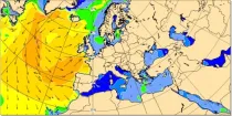
At any location over the oceans, there is a spectrum of waves which describes how much wave energy is present for given wave frequencies and direction of propagation...

calendar_today Interval/period: N/A

open_in_newview in Open Charts

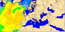
Significant wave height can be shown to correspond to the average wave height of the top one-third highest waves. The wave period of windsea is generally <10s,...

calendar_today Interval/period: N/A

open_in_newview in Open Charts

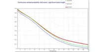
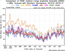
These diagrams compare Continuous Ranked Probability Skill Scores (CRPSS) of ECMWF with ...

calendar_today Interval/period: N/A

open_in_newview in Open Charts
The Surface Radiation Budget (SRB) represents the balance between the heating of the Earth’s surface through absorption of incoming solar radiation and cooling through the emission of infra-red radiation, which is a fundamental component of the surface energy budget. Small changes in the surface radiation budget can lead to large climatological responses, which makes a permanent and precise monitoring indispensable.

calendar_today Interval/period: Mon, 01/01/1979 - Mon, 06/30/2025

This dataset contains a set of synthetic windstorm events consisting of 22,980 individual storm footprints over Europe. These are a physically realistic set of plausible windstorm events based on the modelled climatic conditions. It is not designed to reproduce actual historical observations but as a comparator for the stochastic event sets generally used for windstorm risk analysis in the insurance industry. This is because there is no data assimilation process used to align the model output to historical observations.

calendar_today Interval/period: Wed, 01/01/1986 - Wed, 11/30/2011

This dataset provides precipitation and near surface air temperature for Europe as Essential Climate Variables (ECVs) and as a set of Climate Impact Indicators (CIIs) based on the ECVs.
ECV datasets provide the empirical evidence needed to understand the current climate and predict future changes.
CIIs contain condensed climate information which facilitate relatively quick and efficient subsequent analysis. Therefore, CIIs make climate information accessible to application focussed users within a sector.

calendar_today Interval/period: N/A

This dataset provides high-resolution gridded temperature and precipitation observations from a selection of sources. Additionally the dataset contains daily global average near-surface temperature anomalies. All fields are defined on either daily or monthly frequency. The datasets are regularly updated to incorporate recent observations. The included data sources are commonly known as GISTEMP, Berkeley Earth, CPC and CPC-CONUS, CHIRPS, IMERG, CMORPH, GPCC and CRU, where the abbreviations are explained below.

calendar_today Interval/period: Thu, 01/01/1750 - Fri, 01/01/2021

This dataset contains temperature exposure statistics for Europe (e.g. percentiles) derived from the daily 2 metre mean, minimum and maximum air temperature for the entire year, winter (DJF: December-January-February) and summer (JJA: June-July-August). These statistics were derived within the C3S European Health service and are available for different future time periods and using different climate change scenarios.

calendar_today 
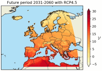
Interval/period: Wed, 01/01/1986 - Mon, 12/31/2085

This dataset provides a complete historical reconstruction for a set of indices representing human thermal stress and discomfort in outdoor conditions. This dataset, also known as ERA5-HEAT (Human thErmAl comforT) represents the current state-of-the-art for bioclimatology data record production.
The dataset is organised around two main variables:

the mean radiant temperature (MRT)
the universal thermal climate index (UTCI)

calendar_today Interval/period: Fri, 12/01/1939 - Sat, 05/02/2026

This catalogue entry provides a time series of thermal comfort indices, organised to make time the primary dimension for analysis and extraction. For any user-defined location (point) or small area, the dataset returns the temporal evolution of the selected variables, enabling efficient time-series studies without requiring users to download and manage full global gridded files.

calendar_today Interval/period: Mon, 01/01/1940 - Fri, 05/09/2025

The International Grand Global Ensemble (TIGGE) dataset consists of global medium-range ensemble forecasts from thirteen numerical weather prediction (NWP) centres.
The dataset has been available since October 2006. TIGGE was established as a key component of THORPEX: a World Weather Research Programme to accelerate the improvements in the accuracy of 1-day to 2 week high-impact weather forecasts (THORPEX stands for THe Observing system Research and Predictability EXperiment)

calendar_today Interval/period: Sun, 10/01/2006 - Wed, 05/06/2026