This chart provides information on the verification of forecasts of Accumulated Cyclone Energy ...

calendar_today Interval/period: N/A

open_in_newview in Open Charts

The ECMWF seasonal forecasts (SEAS5) are produced every month with a 51-member ensemble at a ...

calendar_today Interval/period: N/A

open_in_newview in Open Charts
This dataset provides access to two types of ozone observations: total column ozone estimates and vertical profiles of ozone concentration.
The total ozone estimates are based on solar UV radiation measurements made by ground-based spectrophotometers (Dobson or Brewer type spectrophotometers).
The vertical profiles of ozone concentration are estimated primarily using ozonesonde observations.
Data are available for 159 Dobson stations, 109 Brewer stations and 135 ozonesondes stations.

calendar_today Interval/period: Tue, 01/01/1924 - Sat, 05/09/2026

This dataset provides daily mid-morning measurements for Lake Surface Water Temperature (LSWT) derived from satellite observations. LSWT, together with five other variables (lake ice cover and thickness, water leaving reflectance, water level and extent) is recognised as the Essential Climate Variable (ECV) "Lakes" by the Global Climate Observing System (GCOS). LSWT is a key parameter in determining lake ecological conditions as it influences physical, chemical and biological processes.

calendar_today Interval/period: Thu, 06/01/1995 - Sat, 05/09/2026

This dataset provides lake water levels for 311 selected lakes on four continents derived from satellite radar altimetry.

calendar_today Interval/period: Wed, 01/01/1992 - Sat, 05/09/2026

This catalogue entry provides access to a continuous series of near-surface climate observations collected in-situ at
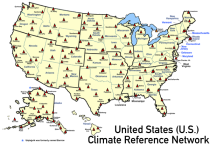
United States Climate Reference Network (USCRN) stations.
There are over 130 USCRN stations over the conterminous United States (U.S.), Alaska, and Hawaii.
The USCRN stations are managed and maintained by the U.S. National Oceanic and Atmospheric Administration (NOAA).
The USCRN observations include air temperature, humidity, wind speed, precipitation, solar radiation,

calendar_today Interval/period: Sun, 01/01/2006 - Sat, 05/09/2026

Mean wave period is the spectrally averaged period of the waves. Wave periods are shown in seconds using colour shading – click on the middle icon to the bottom right for the scale...

calendar_today Interval/period: N/A

open_in_newview in Open Charts
The Essential Climate Variables for assessment of climate variability from 1979 to present dataset contains a selection of climatologies, monthly anomalies and monthly mean fields of Essential Climate Variables (ECVs) suitable for monitoring and assessment of climate variability and change. Selection criteria are based on accuracy and temporal consistency on monthly to decadal time scales.

calendar_today Interval/period: Mon, 01/01/1979 - Wed, 04/01/2026

This dataset contains 4 Essential Climate Variables (ECV) for the 18 bias adjusted Global Climate Models (GCM) from CMIP5: daily precipitation rate, and daily mean, maximum and minimum temperatures.
The data are bias adjusted using the Distribution Based Scaling (DBS) method versus the global reference dataset HydroGFD2.0, both bias adjustment method and global reference dataset developed by the Swedish Meteorological and Hydrological Institute (SMHI).
The DBS method is a parametric quantile-mapping variant.

calendar_today Interval/period: Thu, 10/12/2000 - Thu, 10/18/2018

The dataset presents climate impact indicators related to extreme precipitation in Europe under current climate conditions. The suite of indicators include recent historic records, recurrence intervals, and other relevant statistical measures to evaluate the magnitude and frequency of extreme precipitation events. These are provided as gridded products, with one product covering the whole of Europe, and the other higher resolution product focused on 20 European cities that were identified as vulnerable to urban pluvial flooding based on stakeholder surveys.

calendar_today Interval/period: Sun, 01/01/1950 - Tue, 12/31/2019

The C3S Arctic Regional Reanalysis second generation (CARRA2) dataset contains daily and monthly meteorological variables at 2.5 km resolution. These variables are specified at single levels (including surface) and also at soil, height, pressure and model levels. These daily and monthly data are pre-calculated and have the following types depending on the variables: daily and monthly averages, extremes and totals.

calendar_today Interval/period: Wed, 01/01/1986 - Sun, 12/31/2023

The C3S Arctic Regional Reanalysis second generation (CARRA2) dataset contains 3-hourly analyses at 2.5 km resolution. These variables are specified at single levels (including surface) and also at soil, height, pressure and model levels. Additionally, hourly forecasts are available between the analysis times and particularly forecasts up to 18 hours initialised from the analyses at 00 and 12 UTC.

calendar_today Interval/period: Wed, 01/01/1986 - Sun, 12/31/2023

Within the hydrological cycle, precipitation is the main component of water transport from the atmosphere to the Earth’s surface. Precipitation varies strongly, depending on geographical location, season, synopsis, and other meteorological factors. The supply of freshwater through precipitation is vital for many subsystems of the climate and the environment, but there are also hazards related to extensive precipitation or the lack of precipitation.

calendar_today Interval/period: Mon, 01/01/1979 - Mon, 09/30/2024

This dataset provides global estimates of daily accumulated and monthly means of precipitation. The precipitation estimates are based on a merge of passive microwave observations from two different radiometer classes operating on multiple Low Earth Orbit (LEO) satellites.

calendar_today Interval/period: Sat, 01/01/2000 - Sun, 12/31/2017

This chart shows probability information regarding mean wave period derived from the ECMWF ...

calendar_today Interval/period: N/A

open_in_newview in Open Charts

This chart shows probability information regarding significant wave height derived from the ...

calendar_today Interval/period: N/A

open_in_newview in Open Charts

These charts show the probability of various mean periods of ocean waves 10-15 days ahead. The ...

calendar_today Interval/period: N/A

open_in_newview in Open Charts

The ECMWF seasonal forecasts (SEAS5) are produced every month with a 51-member ensemble at a ...

calendar_today Interval/period: N/A

open_in_newview in Open Charts
The UERRA dataset provides estimations of the climate in Europe based on model data
combined with observations using the UERRA-HARMONIE system and MESCAN-SURFEX system.
UERRA-HARMONIE is a 3-dimensional data assimilation system, whereas
MESCAN-SURFEX is a complementary surface analysis system. In general, the
assimilation systems are able to estimate biases between observations and to
sift good-quality data from poor data. The laws of physics allow for estimates

calendar_today Interval/period: Thu, 10/18/2018 - Wed, 07/31/2019

Mean windsea wave direction is the spectrally averaged direction of propagation of the windsea waves (weighted by wave height). Arrow length is proportional to the speed of wave propagation...

calendar_today Interval/period: N/A

open_in_newview in Open Charts

Significant windsea wave height can be shown to correspond to the average wave height of the top one-third highest windsea waves. Wave heights are shown in metres using colour shading...

calendar_today Interval/period: N/A

open_in_newview in Open Charts
This dataset provides climate indicators of windstorms associated with extratropical cyclones, derived from the fifth generation of the European Centre for Medium-Range Weather Forecasts (ECMWF) atmospheric reanalyses (ERA5) over a pan-European domain. Developed as part of Copernicus Climate Change Service's (C3S) Enhanced Windstorm Service (EWS), and responding to requirements from users in the insurance sector, this dataset extends the previous C3S Windstorm Service (winter months only) to include the entire year.

calendar_today Interval/period: Thu, 02/01/1940 - Fri, 01/23/2026

This dataset provides climatological indicators on European winter windstorms and their economic impact derived from ERA5 reanalysis. Also provided are risk indicators from a synthetically derived set of physically realistic windstorm events based on modelled climatic conditions. The primary users include the insurance sector, reinsurers and insurance industry service providers in response to their requirements for a catalogue of historic windstorm events within Europe.

calendar_today Interval/period: Sat, 03/01/1986 - Wed, 11/30/2011

This dataset provides gridded modelled hydrological time series forced with medium-range meteorological forecasts. The data is a consistent representation of the most important hydrological variables across the European Flood Awareness System (EFAS) domain. The temporal resolution is sub-daily high-resolution and ensemble forecasts of:

River discharge
Volumetric soil moisture
Snow water equivalent
Soil wetness index (root zone)
Runoff water equivalent (surface plus subsurface)

calendar_today Interval/period: Thu, 10/11/2018 - Mon, 04/06/2026

open_in_newview in EWDS

This dataset provides gridded modelled hydrological time series forced with medium-range meteorological forecasts. The data is a consistent representation of the most important hydrological variables across the European Flood Awareness System (EFAS) domain. The temporal resolution is sub-daily high-resolution and ensemble forecasts of:

River discharge
Soil moisture for three soil layers
Snow water equivalent

calendar_today Interval/period: N/A