Datasets
Displaying 1 - 4 of 4
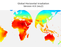
This dataset provides historical values of global, direct and diffuse solar
irradiation, as well as direct normal irradiation, on a latitude/longitude grid
covering land surfaces and coastal areas of Europe, Africa, Oceania, Eastern
South America, the Middle East and South-East Asia. It is created from 15 minute
resolved timeseries at each grid point. These timeseries were calculated by the
CAMS Solar Radiation Time Series Service and use information on aerosol, ozone
Interval/period: Sat, 01/01/2005 - Sun, 12/31/2023
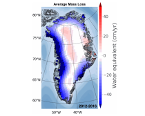
This dataset provides a complete archive of monthly mass change timeseries for the drainage basins of the Antarctic and Greenland Ice Sheets from NASA's Gravity Recovery and Climate Experiment (GRACE) and GRACE Follow On (GRACE-FO) mission, which have operated from 2002 to current data.
Interval/period: Wed, 01/01/2003 - Sat, 12/31/2022
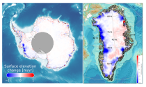
This dataset provides estimates of surface elevation change over the Greenland and Antarctic ice sheets since 1992, utilizing satellite radar altimetry from five missions: ERS-1, ERS-2, ENVISAT, CryoSat-2, and Sentinel-3A. The surface elevation change is modelled over successive, overlapping periods and reported monthly.
Interval/period: Wed, 01/01/1992 - Mon, 05/11/2026
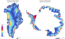
This dataset provides annual ice velocity maps of the Greenland and Antarctic Ice Sheets derived from Sentinel-1 data. The product represents the current state-of-the-art in Europe for satellite-based ice velocity data records. It follows from the European Space Agency (ESA) Climate Change Initiative (CCI) and is guided by the Global Climate Observing System (GCOS) targets for the Ice Sheets Essential Climate Variable (ECV).
Interval/period: Sun, 10/01/2017 - Mon, 05/11/2026