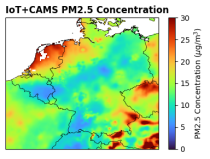
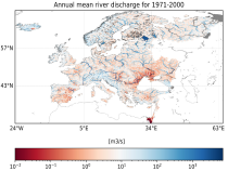
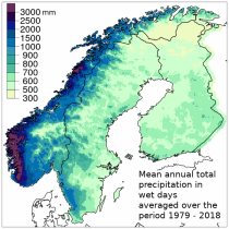
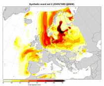
This dataset provides climate indicators of windstorms associated with extratropical cyclones, derived from the fifth generation of the European Centre for Medium-Range Weather Forecasts (ECMWF) atmospheric reanalyses (ERA5) over a pan-European domain. Developed as part of Copernicus Climate Change Service's (C3S) Enhanced Windstorm Service (EWS), and responding to requirements from users in the insurance sector, this dataset extends the previous C3S Windstorm Service (winter months only) to include the entire year.

calendar_today Interval/period: Thu, 02/01/1940 - Fri, 01/23/2026

This dataset provides climatological indicators on European winter windstorms and their economic impact derived from ERA5 reanalysis. Also provided are risk indicators from a synthetically derived set of physically realistic windstorm events based on modelled climatic conditions. The primary users include the insurance sector, reinsurers and insurance industry service providers in response to their requirements for a catalogue of historic windstorm events within Europe.

calendar_today Interval/period: Sat, 03/01/1986 - Wed, 11/30/2011

This dataset, also known as the Long-term Alpine Precipitation Reconstruction (LAPrec), provides gridded fields of monthly precipitation for the Alpine region (eight countries). The dataset is derived from station observations and is provided in two issues:

LAPrec1871 starts in 1871 and is based on data from 85 input series;
LAPrec1901 starts in 1901 and is based on data from 165 input series.

calendar_today Interval/period: Sun, 01/01/1871 - Sat, 05/09/2026

The Copernicus European Regional ReAnalysis (CERRA) datasets provide spatially and temporally consistent historical reconstructions of meteorological variables in the atmosphere and at the surface. There are four subsets: single levels (atmospheric and surface quantities), height levels (upper-air fields up to 500m), pressure levels (upper-air fields up to 1hPa) and model levels (native levels of the model). This entry provides reanalysis and forecast data on single levels for Europe from 1984 to present.

calendar_today Interval/period: Sat, 09/01/1984 - Sat, 01/31/2026

The Copernicus European Regional ReAnalysis Land (CERRA-Land) dataset provides spatially and temporally consistent historical reconstructions of surface and soil variables at the same horizontal resolution as the CERRA high-resolution reanalysis.

calendar_today Interval/period: Sat, 09/01/1984 - Thu, 07/31/2025

The Copernicus climate change service (C3S) operational energy dataset provides climate and energy indicators for the European energy sector. The climate-relevant indicators for the energy sector considered are: air temperature, precipitation, incoming solar radiation, wind speed at 10 m and 100 m, and mean sea level air pressure. The energy indicators are electricity demand and power generation from various sources: wind (both onshore and offshore), solar and hydro (run-of-river and reservoir) power.

calendar_today Interval/period: Mon, 01/01/1979 - Sun, 03/01/2026

This dataset provides climate and energy indicators for the Europe as part of the Copernicus climate change service (C3S) Energy operational service. The climate-relevant indicators for the energy sector considered are: air temperature, precipitation, incoming solar radiation, wind speed at 10 m and 100 m, and mean sea level air pressure. The energy indicators are electricity demand and power generation from various sources: wind (both onshore and offshore), solar and hydro (run-of-river and reservoir) power.

calendar_today Interval/period: N/A

The Pan-European Climate Database (PECD) provides information on climate and renewable energy variables for both historical and future time periods. For historical data, the ERA5 global reanalysis serves as the underlying climate data, while future projections are based on selected CMIP6 global climate models. The raw climate model data are further processed through downscaling to achieve higher spatial and temporal resolution and by applying bias adjustment.

calendar_today Interval/period: Sun, 01/01/1950 - Wed, 12/01/2100

This dataset provides a series of climate indices derived from reanalysis and model simulations data hosted on the Copernicus Climate Data Store (CDS). These indicators describe how climate variability and change of essential climate variables can impact sectors such as health, agriculture, forestry, energy, tourism, or water and coastal management.

calendar_today Interval/period: Mon, 01/01/1940 - Fri, 12/31/2100

This catalogue entry provides Regional Climate Model (RCM) data on single levels from a number of experiments, models, domains, resolutions, ensemble members, time frequencies and periods computed over several regional domains all over the World in the framework of the Coordinated Regional Climate Downscaling Experiment (CORDEX). The term "single levels" is used to express that the variables are 2D-matrices computed on one vertical level which can be surface (or a level close to the surface) or a dedicated pressure level in the atmosphere.

calendar_today Interval/period: Sun, 01/01/1950 - Fri, 12/31/2100

E-OBS is a daily gridded land-only observational dataset over Europe. The blended time series from the station network of the European Climate Assessment & Dataset (ECA&D) project form the basis for the E-OBS gridded dataset. All station data are sourced directly from the European National Meteorological and Hydrological Services (NMHSs) or other data holding institutions.

calendar_today Interval/period: Sun, 01/01/1950 - Sat, 05/09/2026

The dataset contains the number of hot and cold spell days using different European-wide and national/regional definitions developed within the C3S European Health service.
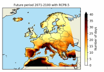
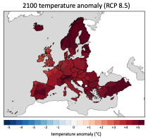
These heat wave and cold spell days are available for different future time periods and use different climate change scenarios.

calendar_today Interval/period: Wed, 01/01/1986 - Mon, 12/31/2085

This dataset provides surface-level particulate matter (PM2.5 and PM10) concentrations derived from in situ low-cost sensor (LCS) measurements, produced by the European Centre for Medium-Range Weather Forecasts (ECMWF) in the context of the Horizon Europe All Data for Green Deal project. This dataset differs from existing air quality datasets by combining crowdsourced observations with a robust correction framework, producing high-resolution, reference-aligned gridded products.

calendar_today Interval/period: Mon, 01/01/2018 - Tue, 12/31/2024

open_in_newview in XDS
This dataset provides water variables and indicators based on hydrological impact modelling, forced by bias adjusted regional climate simulations from the European Coordinated Regional Climate Downscaling Experiment (EURO-CORDEX). The dataset contains Essential Climate Variable (ECV) data in the form of daily mean river discharge and a set of climate impact indicators (CIIs) for both water quantity and quality.
ECV datasets provide the empirical evidence needed to understand the current climate and predict future changes.

calendar_today Interval/period: N/A

The Nordic Gridded Climate Dataset (NGCD) is a high resolution, observational, gridded dataset of daily minimum, maximum and mean temperatures and daily precipitation totals, covering Finland, Sweden and Norway. The time period covered begins in January 1961 and continues to the present.
Spatial interpolation methods are applied to observational datasets to create gridded datasets.
In general, there are three types of such methods: deterministic (type 1), stochastic (type 2) and pure mathematical (type 3).

calendar_today Interval/period: Sun, 01/01/1961 - Thu, 09/18/2025

This dataset contains a set of synthetic windstorm events consisting of 22,980 individual storm footprints over Europe. These are a physically realistic set of plausible windstorm events based on the modelled climatic conditions. It is not designed to reproduce actual historical observations but as a comparator for the stochastic event sets generally used for windstorm risk analysis in the insurance industry. This is because there is no data assimilation process used to align the model output to historical observations.

calendar_today Interval/period: Wed, 01/01/1986 - Wed, 11/30/2011

This dataset provides precipitation and near surface air temperature for Europe as Essential Climate Variables (ECVs) and as a set of Climate Impact Indicators (CIIs) based on the ECVs.
ECV datasets provide the empirical evidence needed to understand the current climate and predict future changes.
CIIs contain condensed climate information which facilitate relatively quick and efficient subsequent analysis. Therefore, CIIs make climate information accessible to application focussed users within a sector.

calendar_today Interval/period: N/A

This dataset contains temperature exposure statistics for Europe (e.g. percentiles) derived from the daily 2 metre mean, minimum and maximum air temperature for the entire year, winter (DJF: December-January-February) and summer (JJA: June-July-August). These statistics were derived within the C3S European Health service and are available for different future time periods and using different climate change scenarios.

calendar_today Interval/period: Wed, 01/01/1986 - Mon, 12/31/2085