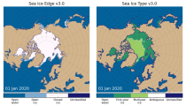
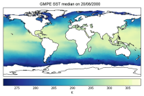
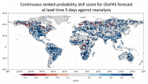
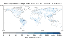
This dataset provides daily mid-morning measurements for Lake Surface Water Temperature (LSWT) derived from satellite observations. LSWT, together with five other variables (lake ice cover and thickness, water leaving reflectance, water level and extent) is recognised as the Essential Climate Variable (ECV) "Lakes" by the Global Climate Observing System (GCOS). LSWT is a key parameter in determining lake ecological conditions as it influences physical, chemical and biological processes.

calendar_today Interval/period: Thu, 06/01/1995 - Mon, 05/11/2026

This dataset provides lake water levels for 311 selected lakes on four continents derived from satellite radar altimetry.

calendar_today Interval/period: Wed, 01/01/1992 - Mon, 05/11/2026

This dataset provides daily gridded data of sea ice concentration for both hemispheres derived from satellite passive microwave brightness temperatures. Sea ice is an important component of our climate system and a sensitive indicator of climate change. Its presence or its retreat has a strong impact on air-sea interactions, the Earth’s energy budget as well as marine ecosystems. It is recognised by the Global Climate Observing System as an Essential Climate Variable.

calendar_today Interval/period: Sun, 10/01/1978 - Mon, 09/29/2025

This dataset provides daily gridded fields of sea ice drift vectors for both hemispheres derived from satellite passive microwave brightness temperatures and atmospheric reanalysis data. Sea ice is an important component of our climate system and a sensitive indicator of climate change. Its presence or retreat significantly affects ocean-atmosphere interactions, the Earth’s energy budget as well as marine ecosystems. It is classified as an Essential Climate Variable by the Global Climate Observing System.

calendar_today Interval/period: Tue, 01/01/1991 - Thu, 12/31/2020

This dataset provides daily gridded data of sea ice edge and sea ice type derived from brightness temperatures measured by satellite passive microwave radiometers. Sea ice is an important component of our climate system and a sensitive indicator of climate change. Its presence or its retreat has a strong impact on air-sea interactions, the Earth’s energy budget as well as marine ecosystems. It is recognized by the Global Climate Observing System as an Essential Climate Variable. Sea ice edge and type are some of the parameters used to characterise sea ice.

calendar_today Interval/period: Wed, 10/25/1978 - Wed, 09/24/2025

This dataset provides daily and monthly sea ice surface temperature (IST) fields over the polar oceans from 1982 to the present. The data are derived from thermal infrared measurements from a single satellite sensor type: the Advanced Very High Resolution Radiometer (AVHRR) onboard National Oceanic and Atmospheric Administration (NOAA) and Meteorological Operational (MetOp) satellites.

calendar_today Interval/period: Mon, 01/01/1979 - Tue, 09/30/2025

This dataset provides gridded sea ice thickness data for the Arctic, derived from satellite observations. Sea ice plays a vital role in the climate system, influencing air-sea interactions, the Earth’s energy balance, and marine ecosystems. It is recognised by the Global Climate Observing System (GCOS) as an Essential Climate Variable (ECV). Sea ice thickness is a key characteristic used alongside other parameters such as concentration, edge, and type, all available in the Climate Data Store (CDS).

calendar_today 
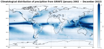
Interval/period: Tue, 10/01/2002 - Sat, 04/12/2025

This dataset provides gridded daily and monthly mean global estimates of sea level anomaly based on satellite altimetry measurements. The rise in global mean sea level in recent decades has been one of the most important and well-known consequences of climate warming, putting a large fraction of the world population and economic infrastructure at greater risk of flooding. However, changes in the global average sea level mask regional variations that can be one order of magnitude larger.

calendar_today Interval/period: Fri, 01/01/1993 - Sun, 12/31/2023

This dataset provides global daily sea surface temperature (SST) data from the Group for High Resolution Sea Surface Temperature (GHRSST) multi-product ensemble (GMPE) produced by the European Space Agency SST Climate Change Initiative (ESA SST CCI). The GMPE system was designed to allow users to compare the outputs from different SST analysis systems and understand their similarities and differences. Although originally intended for comparison of near real time data, it has also been used to compare long historical datasets.

calendar_today Interval/period: Tue, 09/01/1981 - Sat, 12/31/2016

The Essential Climate Variables for assessment of climate variability from 1979 to present dataset contains a selection of climatologies, monthly anomalies and monthly mean fields of Essential Climate Variables (ECVs) suitable for monitoring and assessment of climate variability and change. Selection criteria are based on accuracy and temporal consistency on monthly to decadal time scales.

calendar_today Interval/period: Mon, 01/01/1979 - Wed, 04/01/2026

Within the hydrological cycle, precipitation is the main component of water transport from the atmosphere to the Earth’s surface. Precipitation varies strongly, depending on geographical location, season, synopsis, and other meteorological factors. The supply of freshwater through precipitation is vital for many subsystems of the climate and the environment, but there are also hazards related to extensive precipitation or the lack of precipitation.

calendar_today Interval/period: Mon, 01/01/1979 - Mon, 09/30/2024

This dataset provides global estimates of daily accumulated and monthly means of precipitation. The precipitation estimates are based on a merge of passive microwave observations from two different radiometer classes operating on multiple Low Earth Orbit (LEO) satellites.

calendar_today Interval/period: Sat, 01/01/2000 - Sun, 12/31/2017

This dataset provides an ensemble of forecast time series of gridded hydrological data. The data set is a product of the Global Flood Awareness System (GloFAS) and offers a consistent representation of key hydrological variables across the global domain including:

River discharge
Soil wetness index (root zone)
Snow water equivalent
Runoff water equivalent (surface plus subsurface)

calendar_today Interval/period: Tue, 11/05/2019 - Thu, 05/07/2026

open_in_newview in EWDS
This dataset provides gridded modelled daily hydrological time series forced with meteorological reanalysis data. The data set is a product of the Global Flood Awareness System (GloFAS) and offers a consistent representation of key hydrological variables across the global domain including:

River discharge
Soil wetness index (root zone)
Snow water equivalent
Runoff water equivalent (surface plus subsurface)

calendar_today Interval/period: Mon, 01/01/1979 - Tue, 05/05/2026

The Sub-seasonal To Seasonal dataset (S2S) consists of global ensemble real-time forecasts and reforecasts from thirteen numerical weather prediction (NWP) and research centres.
S2S project behind the dataset started in 2013 as a joint initiative of the World Weather Research Programme (WWRP) and the World Climate Research Programme (WCRP).
The goal of S2S project was to improve sub-seasonal forecast skill through combining multiple forecasting systems, enable multi-model evaluations and enhance knowledge sharing between operational centres.

calendar_today Interval/period: Thu, 01/01/2015 - Wed, 05/06/2026

The Sub-seasonal To Seasonal dataset (S2S) consists of global ensemble real-time forecasts and reforecasts from thirteen numerical weather prediction (NWP) and research centres.
S2S project behind the dataset started in 2013 as a joint initiative of the World Weather Research Programme (WWRP) and the World Climate Research Programme (WCRP).
The goal of S2S project was to improve sub-seasonal forecast skill through combining multiple forecasting systems, enable multi-model evaluations and enhance knowledge sharing between operational centres.

calendar_today Interval/period: Tue, 03/01/2011 - Tue, 06/09/2026

This dataset provides a gridded modelled time series of river discharge, forced with medium- to sub-seasonal range meteorological reforecasts. The data is a consistent representation of a key hydrological variable across the global domain, and is a product of the Global Flood Awareness System (GloFAS). It is accompanied by an ancillary file for interpretation that provides the upstream area (see the related variables table and associated link in the documentation).

calendar_today Interval/period: Sun, 01/03/1999 - Sat, 11/25/2023

This dataset provides daily and monthly fields of global sea surface temperature (SST) and sea ice surface temperature (IST) from 1982 to the present, using observations from multiple infrared and passive microwave satellite sensors. SST is a key driver of global weather and climate, affecting ocean-atmosphere interactions and driving climate variability.

calendar_today Interval/period: Fri, 01/01/1982 - Tue, 12/31/2024

This dataset provides global estimates of precipitation based on satellite observations. Precipitation is the main component of water transport from the atmosphere to the Earth’s surface within the hydrological cycle. It varies strongly, depending on geographical location, season, synopsis, and other meteorological factors. The supply with freshwater through precipitation is vital for many subsystems of the climate and the environment, but there are also hazards related to extensive precipitation or the lack of precipitation.

calendar_today Interval/period: Tue, 01/01/2002 - Sat, 12/31/2022

ERA5-Land is a reanalysis dataset providing a consistent view of the evolution of land variables over several decades at an enhanced resolution compared to the
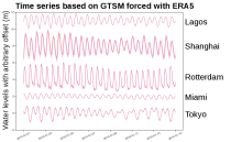
Fifth Generation of the European Centre for Medium-Range Weather Forecasts (ECMWF) Reanalysis (ERA5).
Produced by replaying only the land component of the ECMWF ERA5 climate reanalysis, it benefits from the same physical data-assimilation framework but runs offline at
higher spatial detail (9 km grid) to deliver richer land-surface information.

calendar_today Interval/period: Sun, 01/01/1950 - Thu, 12/31/2026

ERA5-Land is a reanalysis dataset providing a consistent view of the evolution of land variables over several decades at an enhanced resolution compared to ERA5. ERA5-Land has been produced by replaying the land component of the ECMWF ERA5 climate reanalysis. Reanalysis combines model data with observations from across the world into a globally complete and consistent dataset using the laws of physics. Reanalysis produces data that goes several decades back in time, providing an accurate description of the climate of the past.

calendar_today Interval/period: Sun, 01/01/1950 - Sat, 05/02/2026

ERA5-Land is a reanalysis dataset providing a consistent view of the evolution of land variables over several decades at an enhanced resolution compared to ERA5. ERA5-Land has been produced by replaying the land component of the ECMWF ERA5 climate reanalysis. Reanalysis combines model data with observations from across the world into a globally complete and consistent dataset using the laws of physics. Reanalysis produces data that goes several decades back in time, providing an accurate description of the climate of the past.

calendar_today Interval/period: Sun, 01/01/1950 - Wed, 04/01/2026

ERA5-Land is a reanalysis dataset providing a consistent view of the evolution of land variables over several decades at an enhanced resolution compared to ERA5. ERA5-Land has been produced by replaying the land component of the ECMWF ERA5 climate reanalysis. Reanalysis combines model data with observations from across the world into a globally complete and consistent dataset using the laws of physics. Reanalysis produces data that goes several decades back in time, providing an accurate description of the climate of the past.

calendar_today Interval/period: Sun, 01/01/1950 - Sat, 05/02/2026

This dataset provides statistical indicators of tides, storm surges and sea level that can be used to characterize global sea level in present-day conditions and also to assess changes under climate change. The indicators calculated include extreme-value indicators (e.g. return periods including confidence bounds for total water levels and surge levels), probability indicators (e.g. percentile for total water levels and surge levels).

calendar_today Interval/period: Mon, 01/01/1951 - Sat, 12/31/2050

This dataset provides time series of global sea level related variables including tides, storm surges and sea level rise from 1950 to 2050 based on hydrodynamic modelling. The dataset provides a basis for studies, for instance, aiming to evaluate sea level variability, coastal flooding, coastal erosion, and accessibility of ports.

calendar_today Interval/period: Sun, 01/01/1950 - Sat, 12/31/2050