
Bruce Ingleby, ECMWF Senior Scientist, Earth System Assimilation Section
Recently ECMWF has provided input to the World Meteorological Organization (WMO) in support of its new Systematic Observations Financing Facility (SOFF) which will support countries to generate and exchange basic observational data critical for improved weather forecasts and climate services. For medium-range weather forecasting, global observation coverage is vital - poor six-day forecasts over Europe can be traced back to errors originating in the tropical east Pacific or Canada (Magnusson, 2017).
The ECMWF Integrated Forecasting System assimilates a wide range of observations to help define the initial conditions at the start of a forecast run. Accurate initial conditions are vital for skilful forecasts. Recent Observing System Experiments (OSEs) at ECMWF (Bormann, Lawrence and Farnan, 2019) have reconfirmed the importance of surface-based (or ‘conventional’) observations: aircraft, radiosondes and surface stations both land and marine. They remain more important than the single most impactful satellite data type (microwave radiances) in the northern hemisphere, especially for short-range forecasts.
OSEs allow us to investigate the impact of some of the main observing systems in the ECMWF assimilation system. They involve a series of assimilation experiments in which selected observing systems are withheld from the assimilation and the results are compared to those from an experiment with the full observing system.
Unexpectedly, the Covid pandemic provided us with an opportunity to look specifically at the impact of observation reports from aircraft. With international partners we have looked at whether the loss of aircraft reports has caused any loss of forecast skill (Ingleby et al, 2021). There is no obvious loss of skill in the verification time-series - which continue to show long-term improvements due to the combined effect of model, data assimilation and observation changes. There are day-to-day and year-to-year variations in forecast skill that complicate such assessments. Results suggest that upper tropospheric forecasts in 2020 would have been even better with a ‘normal’ level of aircraft data.
In Figure 1, a map from the study by Bormann, Lawrence and Farnan (but not shown in their paper), illustrates how forecast errors increase if all surface-based observations are removed. This is shown for 24-hour forecasts of vector wind at 850 hPa (between 1 and 2 km height). At this forecast range, the largest impact is generally found close to, or just downwind of, observing stations. The details of such forecast impact maps will change from one period to another, depending on the predominant synoptic patterns. In this example, Figure 1 is averaged over 464 forecasts between June 2016 and March 2018, to capture a wide range of synoptic events.
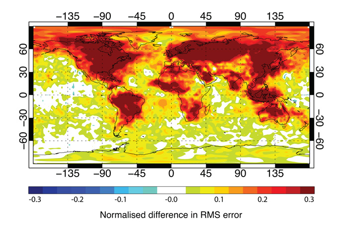
Figure 1: Normalised change in the difference between the 24-hour forecast and verifying analysis of vector wind at 850 hPa when surface-based observations are withheld. Positive values indicate larger differences when observations are withdrawn.
These impacts can be compared to surface-based observation coverage (Figure 2). For marine surface data see Ingleby and Isaksen (2018). There is broad correspondence between the regions of high observation density and impact on the 24-hour forecasts. The largest impact is seen in the eastern part of North America (impact further west is reduced, as there are few surface observations over the Pacific), over Eastern Europe and North Asia and in some specific regions such as eastern South America, Australia and China. Much of Africa has low impact, because there are fewer observations. In general, impact is less in western coastal regions (in both North and South America, and Europe), due to low numbers of surface-based observations over the ocean, and the prevailing wind direction.
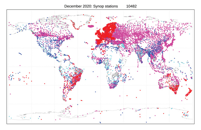
Figure 2: Active land surface stations (SYNOPs), December 2020. The colour gives the frequency of reports received: grey - fewer than 2/day through to red - 24/day. The WMO Integrated Global Observing System (WIGOS) is now encouraging the global exchange of hourly reports.
We can also look at the impact of individual observations. For example, we can look at the contribution to forecast error reduction for a 24-hour forecast using a diagnostic known as Forecast Sensitivity Observation Impact (FSOI, Langland and Baker, 2004 and Cardinali, 2009). We can then compare the contribution of individual observing stations in different regions. By this measure, satellites gave about 74% of total observation impact in 2019 and surface-based observations gave 26%.
In Figures 3 and 4 radiosonde and SYNOP FSOI is compared between Pacific Island stations where in situ reports are very sparse, and selected continental areas, where there is a high density of stations (Figure 5). It is found that the isolated stations have a much larger contribution to forecast error reduction than any one station in the well observed regions (reporting frequency, or the vertical resolution of radiosonde reports, also plays a role). This result reconfirms the importance of obtaining observations in less well observed areas, in turn underlying the importance of global coverage by the Global Observing System.
ECMWF monitors the ‘health’ of observing systems on a daily basis and provides feedback to data providers as necessary. Recently we started using data from the new Kenyan AMDAR (aircraft) programme, which provides important wind information in a relatively data sparse area.
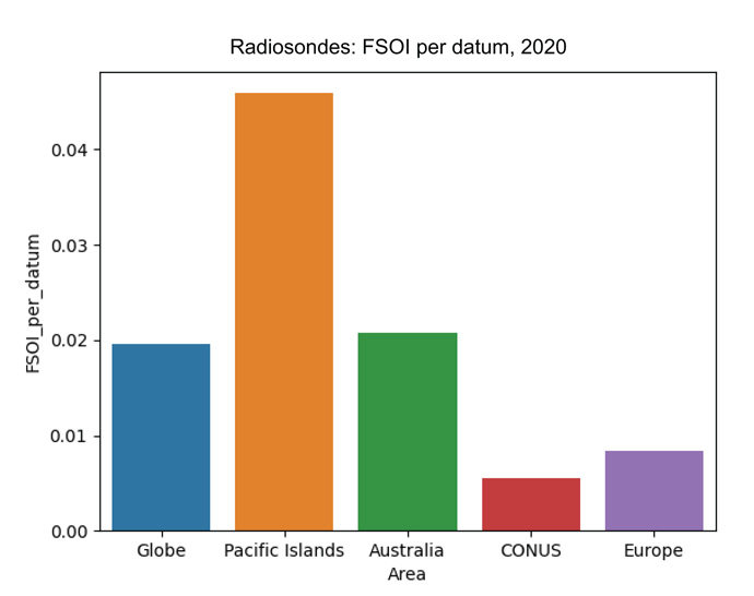
Figure 3: Radiosonde FSOI per datum for 2020 for various regions. CONUS = contiguous USA.
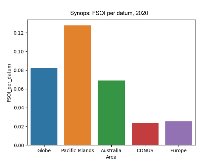
Figure 4: FSOI per datum for SYNOP stations in 2020 - various regions. CONUS = contiguous USA.
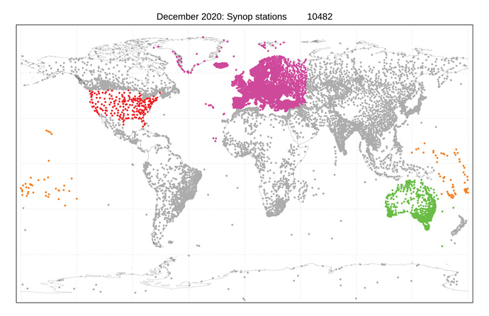
Figure 5: Map showing the regions used in Figures 3 and 4 (based on WMO ‘blocks’ and a 50°E limit for Europe). Results have been combined for alphanumeric and binary (BUFR) reports. The migration to binary reporting is about 85% complete for SYNOPs and about 70% complete for radiosonde stations. See more details.
Conclusions
- All observing systems (surface-based observations and data from various satellite instruments) provide significant positive impact for at least some aspects of the numerical weather prediction (NWP) system. The results confirm the overall complementarity of the global observing system (Bormann et al, 2019).
- Surface-based observations and microwave radiances are the main drivers of headline scores (which are used to measure the skill of NWP forecasts).
- Surface-based observations have their largest impact over the northern extratropics where they are densest, but strong impacts were also found in the tropics, which appears remarkable given the low data numbers.
- Of the observing systems considered, surface-based observations have the largest impact on the mean state of the analysis.
The OSEs described here underline the importance of filling gaps in surface-based observations as much as possible.
There is, however, ample evidence of the need to invest more in determining the impact of existing and, possibly even more importantly, future observations.
References
Bormann N, H. Lawrence and J. Farnan, 2019: Global observing system experiments in the ECMWF assimilation system, ECMWF Tech Memo 839. https://www.ecmwf.int/en/elibrary/80953-global-observing-system-experiments-ecmwf-assimilation-system. DOI 10.21957/sr184iyz.
Cardinali, C., 2009: Monitoring the observation impact on the short-range forecast. Q. J. R. Meteorol. Soc., 135, 239–250, https://doi.org/10.1002/qj.366.
Ingleby, B., and L. Isaksen, 2018: Drifting buoy pressures: Impact on NWP. Atmos. Sci. Lett., 19, https://doi.org/10.1002/asl.822.
Ingleby, B., B. Candy, J. Eyre, T. Haiden, C. Hill, L. Isaksen, D. Kleist, F. Smith, P. Steinle, S. Taylor, W. Tennant, and C. Tingwell, 2021: The impact of COVID-19 on weather forecasts: a balanced view. Geophys. Res. Let., https://doi.org/10.1029/2020GL090699.
Langland, R.H. and Baker, N.L. (2004), Estimation of observation impact using the NRL atmospheric variational data assimilation adjoint system. Tellus A, 56: 189-201. https://doi.org/10.1111/j.1600-0870.2004.00056.x.
Magnusson, L. (2017), Diagnostic methods for understanding the origin of forecast errors. Q.J.R. Meteorol. Soc, 143: 2129-2142. https://doi.org/10.1002/qj.3072.