
ECMWF forecasts have helped researchers in the United States to plan the deployment of aircraft in a field experiment on tropical cyclone intensity and structure change.
Professor Sharan Majumdar from the University of Miami and Dr Alan Brammer from the University at Albany explain how ECMWF data guided them to the right locations.
The 2015 Tropical Cyclone Intensity field experiment (TCI-15), funded by the US Office of Naval Research, sampled the upper-level outflow of tropical cyclones in order to reveal new insights into the role that outflow might play in intensity change.
The field experiment involved the deployment of the NASA WB-57 aircraft, which possessed a unique capability to fly over the cyclones and deploy up to 80 dropwindsondes per mission.
Two noteworthy cases were Hurricane Joaquin in the Atlantic basin, which possessed unusually high uncertainty in its forecast, and Hurricane Patricia in the eastern Pacific basin, which was the most intense tropical cyclone ever recorded in the western hemisphere.
Hurricane Joaquin
On 27 September 2015, the TCI team’s focus had been on Hurricane Marty near Mexico.
However, the 00 UTC ECMWF ensemble forecast began to suggest that a loosely organised cluster of thunderstorms north of the Dominican Republic had the potential to develop into a tropical cyclone.
Ensemble forecasts describe the range of possible scenarios and their likelihood of occurrence. They are usually run at a relatively low resolution and can be used in conjunction with high-resolution forecasts, which make a single prediction.


Ensemble ‘postage stamps’ of Hurricane Joaquin. Different members of this three-day high-resolution and ensemble forecast for Joaquin from 00 UTC on 29 September 2015 indicated different scenarios for the strength of the hurricane vortex and outflow configurations.
The indication from ECMWF’s forecast helped convince the TCI team to forward deploy the aircraft, crew and equipment to Georgia in the eastern United States in order to prepare for missions over the disturbance that ultimately became Hurricane Joaquin.
The consistency in ECMWF’s high-resolution and ensemble output over this period led to increased confidence that this would be an excellent case.
Four WB-57 missions over Joaquin were conducted between 2 and 5 October, including the period when Joaquin was a Category 4 hurricane. ECMWF’s high-resolution forecasts were the earliest of all forecasts from operational models to capture the correct track of the hurricane.
Hurricane Patricia
ECMWF’s high-resolution and ensemble forecasts were also used to guide the planning of the historic missions into Hurricane Patricia, which possessed a minimum sea-level pressure of 872 hPa and a maximum sustained wind speed of 95 m/s on 23 September 2015.
The time-sensitive decision on deployment, which resulted in four successful WB-57 missions, can again be attributed in large part to the quality of the forecast guidance.
The retrospective consensus view of the TCI-15 team is that all the decisions on deployment or non-deployment turned out to be the correct call, which speaks to the effectiveness of the model guidance.

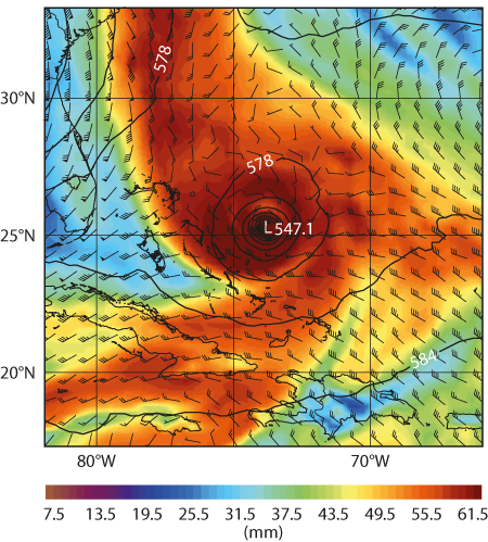
High-resolution forecast of Hurricane Joaquin. ECMWF’s 4-day high-resolution forecast of total precipitable water (shading), 200 hPa wind (barbs) and 500 hPa height (contours, in decametres) from 00 UTC on 29 September 2015 suggested an intense Hurricane Joaquin with outflow towards the north and east.
New products
Beyond the decision of whether or not to deploy, additional decisions on how to design the flight tracks were also necessary.
To address the scientific goal of understanding the role of the upper-tropospheric outflow in tropical cyclone intensity change, new products based on ensemble forecasts were developed and used.
These products demonstrated the range of scenarios, not only of the position and strength of the hurricane, but also of the configuration of the outflow.
Overall, the TCI-15 field experiment benefited substantially from ECMWF’s forecasts, which were the central predictions used during the daily weather briefings.
Now that the field experiment has concluded, investigators are using the data to address scientific questions related to the dynamics and predictability of tropical cyclones.
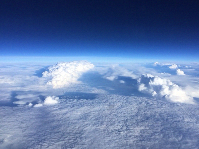
Top photo (courtesy of Joe Gerky): Looking down on Hurricane Patricia from aboard the WB-57 aircraft.
