
Moderate El Niño conditions seen since this spring are continuing to strengthen and are likely to turn into a very strong event by the end of 2015, current forecasts suggest.
An El Niño event is a prolonged period of abnormally high sea-surface temperatures in the tropical Pacific Ocean. It goes hand in hand with changes in atmospheric conditions and can have strong repercussions on global weather patterns. El Niño can also significantly affect the global average temperature and hence influence the global warming signal.
El Niño events vary in amplitude, and very strong events are rare, occurring only a few times per century. Since 1950, end of year anomalies above 2 °C have occurred only in 1972, 1982 and 1997. Such extreme and rare events pose a major forecasting challenge.
The story so far
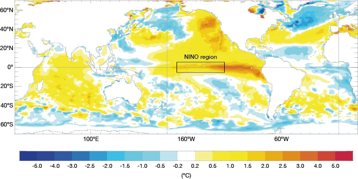
Relative to the 1981–2010 average, the sea-surface temperature anomaly in the NINO3.4 region has increased steadily since March this year to reach about 1.6 °C in July. This is the highest July anomaly since 1997.

Average sea-surface temperature anomalies in July 2015. The chart shows sea-surface temperature anomalies compared to the 1981–2009 average.
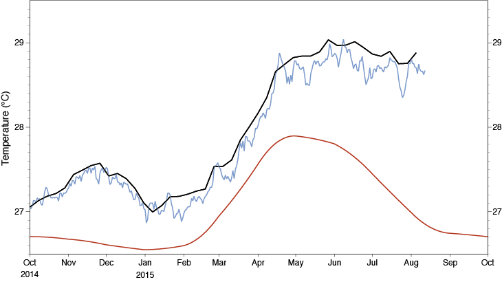
Observed sea-surface temperatures in the NINO3.4 region have been higher than the climatological average since last year but, as the chart below shows, the gap between observed and average values has significantly widened over the last few months.

Average and observed sea-surface temperatures. The chart shows the average evolution of sea-surface temperatures in the NINO3.4 region based on the years 1981 to 2010 (red line) and the observed evolution since October 2014 according to two different analyses (dark and light blue lines). The difference between the red and blue lines is the sea-surface temperature anomaly.
Latest forecasts
El Niño events typically peak near the end of the year. ECMWF’s latest seasonal ensemble forecast from 1 August 2015 suggests that this year will be no exception. Ensemble forecasts account for the uncertainties inherent in the prediction of weather and ocean parameters by producing a set of possible outcomes.
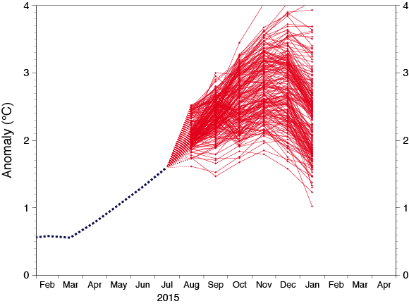
“All ECMWF ensemble members predict an anomaly greater than 2 °C by November. We know that in exceptional events our model can overestimate the anomalies, as happened in 1997. Even so, the latest forecast is stronger than all other forecasts starting in August during the last 34 years, except for that of 1997,” said Tim Stockdale, the head of ECMWF’s Seasonal and Long-Range Forecasting Group.
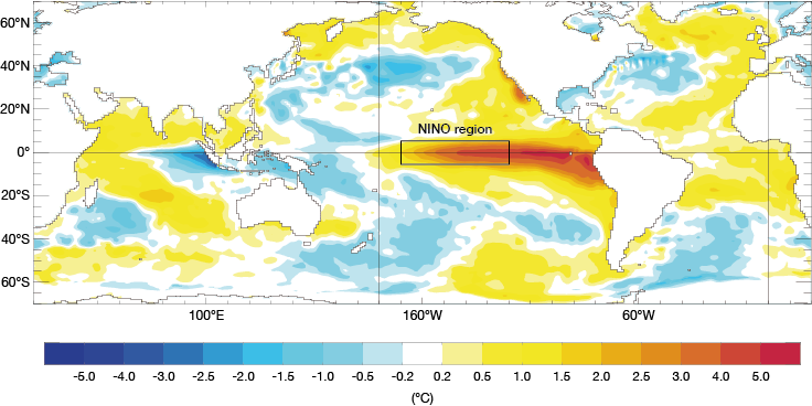
“The 1997 anomaly peaked at almost 2.7 °C, which may not be reached this year, but the 2015 event is still likely to be very strong,” he added.
Experience has shown that, at seasonal timescales, the most reliable forecasts are obtained by combining and calibrating the ensembles from a number of independent forecasting systems. The chart below shows the ensemble El Niño temperature anomalies from the calibrated components of the EUROSIP multi-model seasonal forecasting system. The range of predicted values is similar to that predicted by the ECMWF model alone, and the models are consistent in predicting a high likelihood of anomalies above 2 °C.

EUROSIP ensemble plume of sea-surface temperature anomalies. The chart shows the predicted sea-surface temperature anomalies over the NINO3.4 region produced on 1 August from the ensembles provided by four different forecasting centres: ECMWF, the UK Met Office, Météo-France and the US National Centers for Environmental Prediction.
Some ensemble members produce very large anomalies, with anomalies above 3.3 °C implying NINO3.4 temperatures of 30 °C or higher. Such temperatures are physically unlikely, and forecast anomalies above 3 °C are believed to be largely due to non-linearities detrimentally affecting the model calibration.
"Because they are rare, we have limited experience of how models handle such extreme conditions, so some caution is needed in interpreting the plots shown on the web. We take the EUROSIP forecast to suggest that it is very likely that sea-surface temperature anomalies will be at or above 2 °C by November, and that, although the largest anomalies shown are unrealistic, it is possible that the 1997 record values will be exceeded," Dr Stockdale said.
Possible impacts
Substantial El Niño events are associated with significant changes in weather patterns, especially in areas close to the tropical Pacific. The eastward movement of warm surface waters in the tropical Pacific brings higher pressure and less rain to the western Pacific, and lower pressure and more rain to the eastern Pacific.
El Niño can be linked with increased rainfall in the southern US; drought in parts of the Caribbean, the Philippines and parts of Indonesia, and the risk of drought in Australia, Southern Africa and parts of Brazil; and forest fires in Indonesia and Brazil. The impact on Europe is variable, but for this event the latest EUROSIP forecast charts suggest that a milder and in some places wetter winter may be in store – this will be monitored as we get closer.
El Niño events also release much heat into the atmosphere, increasing the global mean near-surface temperature.
El Niños are not necessarily all doom and gloom. Globally, climate-related disasters do not appear to be any more frequent during El Niño years than at other times, and a study of the consequences of the 1997/98 El Niño in the US concludes that the net economic impact of the event on that country was positive.

Average sea-surface temperature anomalies in November 1997. The chart shows sea-surface temperature anomalies, compared to the 1981–2009 average, at the height of the 1997/98 El Niño event.